Frocester: Difference between revisions
Jump to navigation
Jump to search
No edit summary |
No edit summary |
||
| Line 4: | Line 4: | ||
</googlemap> | </googlemap> | ||
</div> | </div> | ||
'''To Yate''': [[ | '''To Yate''': [[Lapley]]<br> | ||
'''To the North''': [[Peter's Street]] | '''To the North''': [[Peter's Street]] | ||
== History == | |||
Opened on 8th July [[1844]]. A Station Master's house was constructed in [[1847]]. Closed to passengers and goods on 11th December [[1961]]. Frocester signal box closed on 11th May [[1962]]. | |||
== Gallery == | == Gallery == | ||
<gallery> | <gallery> | ||
Image:Frocester1.jpg|A photo of the site of Frocester station taken on an unfortunately sunny winter's day. The surviving station masters house is visible, but all else of the station has been removed. | |||
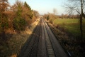
Image:Frocester2.jpg|A similar view, this time pointing down the line to Bristol, rather than directly into the sun. | |||
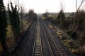
Image:Frocester3.jpg|The view north. | |||
Image:Frocester4.jpg|A zoomed view north showing the bridge at [[Bath Road-Frocester|Bath Road]]. | |||
</gallery> | </gallery> | ||
[[Category:Gloucester:Stations:Closed]] | |||
[[Category:Stations:Closed]] | |||
[[Category:B&GR]] | [[Category:B&GR]] | ||
[[Category:MR]] | [[Category:MR]] | ||
Revision as of 23:19, 29 December 2008
<googlemap lat="51.727407" lon="-2.318276"> 51.72734, -2.318255, Frocester </googlemap>
To Yate: Lapley
To the North: Peter's Street
History
Opened on 8th July 1844. A Station Master's house was constructed in 1847. Closed to passengers and goods on 11th December 1961. Frocester signal box closed on 11th May 1962.
Gallery
-
 A photo of the site of Frocester station taken on an unfortunately sunny winter's day. The surviving station masters house is visible, but all else of the station has been removed.
 -
 A similar view, this time pointing down the line to Bristol, rather than directly into the sun.
 -
 The view north.
 -
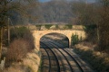 A zoomed view north showing the bridge at Bath Road.


