Lower Fields: Difference between revisions
Jump to navigation
Jump to search
New page: <div style="float:right"> <googlemap lat="51.742868" lon="-2.30052"> 51.73867, -2.30067, Lower Fields </googlemap> </div> '''To Yate''': Bath Road<br> '''To the Nor... |
No edit summary |
||
| Line 5: | Line 5: | ||
</div> | </div> | ||
'''To Yate''': [[Bath Road-Frocester|Bath Road]]<br> | '''To Yate''': [[Bath Road-Frocester|Bath Road]]<br> | ||
'''To the North''': [[]] | '''To the North''': [[Stonehouse (Bristol Road)]] | ||
== Gallery == | == Gallery == | ||
29.12.08 | 29.12.08 | ||
Revision as of 09:00, 5 January 2009
<googlemap lat="51.742868" lon="-2.30052"> 51.73867, -2.30067, Lower Fields </googlemap>
To Yate: Bath Road
To the North: Stonehouse (Bristol Road)
Gallery
29.12.08
-
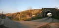
 Lower Fields in the landscape. Bristol is to the left in this photo.
 -
 A closer look at the bridge.
 -
 A Cross Country HST flies past.
 -
 The other side of the bridge.
 -
 The other side in the landscape.


