Mangotsfield South Junction: Difference between revisions
Jump to navigation
Jump to search
No edit summary |
No edit summary |
||
| Line 1: | Line 1: | ||
<div style="float:right"> | |||
<googlemap lat="51.473845" lon="-2.481108"> | |||
51.471506, -2.48203, Mangotsfield South Junction | |||
</googlemap> | |||
</div> | |||
'''To Bristol''': [[Mangotsfield]] | '''To Bristol''': [[Mangotsfield]] | ||
<br>'''To Yate''':[[Mangotsfield North]] | <br>'''To Yate''':[[Mangotsfield North]] | ||
<br>'''To Bath''': [[Siston Hill]] | <br>'''To Bath''': [[Siston Hill]] | ||
== Gallery == | == Gallery == | ||
<gallery> | <gallery> | ||
Image:Mangotsfield South Junction1.jpg|A view of Mangotsfield South Junction taken in 1968. This shows the lines to the station still in situ, the lines to North Junction singled, the old lamp hut and Carson's factory. The spot where this photo was taken is now a rather large roundabout on the Avon Ring Road. ''© Peter Rendall'' | Image:Mangotsfield South Junction1.jpg|A view of Mangotsfield South Junction taken in 1968. This shows the lines to the station still in situ, the lines to North Junction singled, the old lamp hut and Carson's factory. The spot where this photo was taken is now a rather large roundabout on the Avon Ring Road. ''© Peter Rendall'' | ||
</gallery> | </gallery> | ||
[[Category:Bristol and Bath Railway Path]] | [[Category:Bristol and Bath Railway Path]] | ||
[[Category:Junctions]] | [[Category:Junctions]] | ||
[[Category:MR]] | [[Category:MR]] | ||
[[Category:Peter Rendall]] | [[Category:Peter Rendall]] | ||
Revision as of 16:51, 5 November 2007
<googlemap lat="51.473845" lon="-2.481108"> 51.471506, -2.48203, Mangotsfield South Junction </googlemap>
To Bristol: Mangotsfield
To Yate:Mangotsfield North
To Bath: Siston Hill
Gallery
-
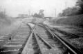 A view of Mangotsfield South Junction taken in 1968. This shows the lines to the station still in situ, the lines to North Junction singled, the old lamp hut and Carson's factory. The spot where this photo was taken is now a rather large roundabout on the Avon Ring Road. © Peter Rendall
