Rodway Hill: Difference between revisions
Jump to navigation
Jump to search
BristleGWR (talk | contribs) No edit summary |
No edit summary |
||
| Line 1: | Line 1: | ||
<div style="float:right"> | <div style="float:right"> | ||
<googlemap lat="51. | <googlemap lat="51.468392" lon="-2.485657"> | ||
51.476067, -2.485989, Rodway Hill | 51.476067, -2.485989, Rodway Hill | ||
</googlemap> | </googlemap> | ||
| Line 14: | Line 14: | ||
Image:Rodway Hill3.jpg|Another train heads south. ''© [[:Category:Clive Moore|Clive Moore]]'' | Image:Rodway Hill3.jpg|Another train heads south. ''© [[:Category:Clive Moore|Clive Moore]]'' | ||
Image:Rodway Hill4.jpg|A Brush type 4 heads south. ''© [[:Category:Clive Moore|Clive Moore]]'' | Image:Rodway Hill4.jpg|A Brush type 4 heads south. ''© [[:Category:Clive Moore|Clive Moore]]'' | ||
</gallery> | |||
== 1970s == | |||
<gallery> | |||
Image:Steve Selwood5.jpg|A photo showing track lifting activities at this location. ''© [[:Category:Steve Selwood|Steve Selwood]]'' | |||
</gallery> | </gallery> | ||
== 2004 == | == 2004 == | ||
| Line 26: | Line 30: | ||
[[Category:Bristol & Gloucestershire Railway]] | [[Category:Bristol & Gloucestershire Railway]] | ||
[[Category:Clive Moore]] | [[Category:Clive Moore]] | ||
[[Category:Steve Selwood]] | |||
Revision as of 20:03, 18 February 2010
<googlemap lat="51.468392" lon="-2.485657"> 51.476067, -2.485989, Rodway Hill </googlemap>
To Bristol: Bridge Road
To Bath or the North: Mangotsfield
History
All the black and white photos were taken during the school summer holidays of 1963 or 1964 by Clive Moore.
1960s
-
 An original Collett 49xx / 59xx series Hall heads for Bristol. © Clive Moore
 -
 While 73091 head north. © Clive Moore
 -
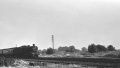 Another train heads south. © Clive Moore
 -
 A Brush type 4 heads south. © Clive Moore


1970s
-
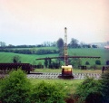 A photo showing track lifting activities at this location. © Steve Selwood

2004
13.4.04
-
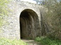
 A footpath passes under the railway at Rodway Hill and leads to Hot Water Lane and Station Road.
 -
 A couple of looks at the southern entrance to the footpath tunnel.
 -