Wickwar Footpath & Aqueduct: Difference between revisions
Jump to navigation
Jump to search
New page: '''To Yate''': Westend Road <br>'''To the North''': Wickwar Tunnel {{gbmapping|ST714877}} == 17.5.05 == <gallery> Image:Westend Road4.jpg|The viaduct (and Wickwar Tunnel) as ... |
No edit summary |
||
| Line 1: | Line 1: | ||
<div style="float:right"> | |||
<googlemap lat="51.588803" lon="-2.414031"> | |||
51.587943, -2.414557, Wickwar Tunnel | |||
</googlemap> | |||
</div> | |||
'''To Yate''': [[Westend Road]] | '''To Yate''': [[Westend Road]] | ||
<br>'''To the North''': [[Wickwar Tunnel]] | <br>'''To the North''': [[Wickwar Tunnel]] | ||
== 17.5.05 == | == 17.5.05 == | ||
<gallery> | <gallery> | ||
Revision as of 11:39, 3 November 2007
<googlemap lat="51.588803" lon="-2.414031"> 51.587943, -2.414557, Wickwar Tunnel </googlemap>
To Yate: Westend Road
To the North: Wickwar Tunnel
17.5.05
-
 The viaduct (and Wickwar Tunnel) as viewed from Westend Road.
 -
 The aqueduct viewed from a footpath that runs through a neighbouring field.
 -
 The view across the aqueduct. A footpath has been constructed on top of the waterway.
 -
 The view south with Westend Road in the distance.
 -
 Zooming in on the bridge at Westend Road.
 -
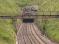
 Looking north at Wickwar Tunnel.
 -
 Zooming in on Wickwar Tunnel.


