M4-2: Difference between revisions
Jump to navigation
Jump to search
Created page with '<div style="float:right"> <googlemap lat="51.492126" lon="-2.449694"> 51.499233, -2.450466, M4 </googlemap> </div> '''To Mangotsfield''': Westerleigh Sidings <br>'''To Yate''…' |
No edit summary |
||
| Line 5: | Line 5: | ||
</div> | </div> | ||
'''To Mangotsfield''': [[Westerleigh Sidings]] | '''To Mangotsfield''': [[Westerleigh Sidings]] | ||
<br>'''To Yate''':[[ | <br>'''To Yate''':[[Parkfield Colliery]] | ||
== 2006 == | == 2006 == | ||
<gallery> | <gallery> | ||
Revision as of 15:43, 30 March 2012
<googlemap lat="51.492126" lon="-2.449694"> 51.499233, -2.450466, M4 </googlemap>
To Mangotsfield: Westerleigh Sidings
To Yate:Parkfield Colliery
2006
-
 The south end of Westerleigh Oil Depot. The M4 crosses the railway on a bridge. The chimney of Parkfield Colliery dominates the horizon.

2012
25.3.12
-
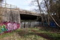 The side of the bridge closest to Parkfield Colliery.
 -
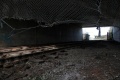 The view north under the bridge.
 -
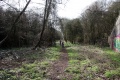 The disused trackbed south of the bridge. At the time the photo was taken this had only recently been cleared.


