St Andrews Road: Difference between revisions
Jump to navigation
Jump to search
No edit summary |
|||
| Line 1: | Line 1: | ||
'''To Avonmouth''': [[Avonmouth Town Goods]]<br> | '''To Avonmouth''': [[Avonmouth Town Goods]]<br> | ||
'''To Hallen Marsh Junction''': [[Holesmouth Junction]] | '''To Hallen Marsh Junction''': [[Holesmouth Junction]] | ||
== Track Plans == | == Track Plans == | ||
<gallery> | <gallery> | ||
| Line 21: | Line 14: | ||
Image:Royal Edward Dock Sidings1.jpg|A [[Class 45|Peak]] enters '''Royal Edward Yard''' from the south. [[Holesmouth Junction|Holesmouth Junction Signal Box]] can be seen in the distance. The Bubble Car scurries towards [[Avonmouth]]. ''© [[:Category:Andy Kirkham|Andy Kirkham]]'' | Image:Royal Edward Dock Sidings1.jpg|A [[Class 45|Peak]] enters '''Royal Edward Yard''' from the south. [[Holesmouth Junction|Holesmouth Junction Signal Box]] can be seen in the distance. The Bubble Car scurries towards [[Avonmouth]]. ''© [[:Category:Andy Kirkham|Andy Kirkham]]'' | ||
</gallery> | </gallery> | ||
== 1980s == | == 1980s == | ||
<gallery> | <gallery> | ||
| Line 32: | Line 24: | ||
Image:St Andrews Road3.jpg|A 1997 view showing the reception sidings in place. This photo was taken from the top of the coal loader. The area covered in coal to the left of the station used to be the '''Royal Edward Yard''' which closed in [[1977]]. ''© [[:Category:Neil Higson|Neil Higson]]'' | Image:St Andrews Road3.jpg|A 1997 view showing the reception sidings in place. This photo was taken from the top of the coal loader. The area covered in coal to the left of the station used to be the '''Royal Edward Yard''' which closed in [[1977]]. ''© [[:Category:Neil Higson|Neil Higson]]'' | ||
</gallery> | </gallery> | ||
== 2003 == | == 2003 == | ||
16.12.03 | 16.12.03 | ||
<gallery> | <gallery> | ||
Image:St Andrews Road5.jpg|The entrance to St Andrews Road station from the road. | Image:St Andrews Road5.jpg|The entrance to St Andrews Road station from the road. | ||
Image:St Andrews Road6.jpg|Standing on the footbridge and looking in the direction of Bristol. The huge loading tower is for coal trains bound for | Image:St Andrews Road6.jpg|Standing on the footbridge and looking in the direction of Bristol. The huge loading tower is for coal trains bound for Didcot Power Station. | ||
Image:St Andrews Road7.jpg|The view of the sidings looking towards Severn Beach. There are 3 [[Class 66|Class 66s]] in this shot, the closest being [[66247]]. | Image:St Andrews Road7.jpg|The view of the sidings looking towards Severn Beach. There are 3 [[Class 66|Class 66s]] in this shot, the closest being [[66247]]. | ||
Image:St Andrews Road8.jpg|The station and platform shelter are somewhat dwarfed by the industrial equipment that surrounds them. | Image:St Andrews Road8.jpg|The station and platform shelter are somewhat dwarfed by the industrial equipment that surrounds them. | ||
| Line 77: | Line 68: | ||
Image:66118-2.jpg|[[66118]] | Image:66118-2.jpg|[[66118]] | ||
</gallery> | </gallery> | ||
== 2018 == | |||
3.5.18 | |||
<gallery> | |||
Image:Standrewsroad30.jpg|With the closure of Didcot Power Station the yard is mostly unused, and was completely empty during my visit. | |||
Image:Standrewsroad31.jpg| | |||
Image:Standrewsroad33.jpg| | |||
Image:Standrewsroad32.jpg|The station itself has been spruced up with the addition of customer service points and rubbish bins etc. | |||
Image:Standrewsroad34.jpg| | |||
Image:Standrewsroad35.jpg| | |||
Image:Standrewsroad36.jpg|[[166207]] heads back to [[Avonmouth]] having made the journey to [[Severn Beach]]. | |||
</gallery> | |||
== Videos == | == Videos == | ||
*[http://uk.youtube.com/watch?v=XnTcZblBvA4 Loading Coal at St Andrews Road] | *[http://uk.youtube.com/watch?v=XnTcZblBvA4 Loading Coal at St Andrews Road] | ||
Revision as of 10:04, 7 May 2018
To Avonmouth: Avonmouth Town Goods
To Hallen Marsh Junction: Holesmouth Junction
Track Plans
-
 A track plan of St Andrews Road and surrounding area from 1988.

1950s
-
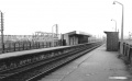 A view of the station looking in the direction of Avonmouth. © Lens of Sutton

1970s
-
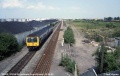
 Class 121 'Bubble Car' 55032 arrives at St Andrews Road with a service from Severn Beach. © Andy Kirkham
 -
 A Peak enters Royal Edward Yard from the south. Holesmouth Junction Signal Box can be seen in the distance. The Bubble Car scurries towards Avonmouth. © Andy Kirkham


1980s
-
 The view from St Andrews Road station footbridge in 1982 looking towards Avonmouth. Avonmouth Goods Yard signal box (Town Goods) and the connections into the freight shed and Fisons can be seen in the background. © P.D.Rendall/Past-Track Publications

1990s
-
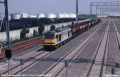
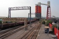
 The view towards Hallen Marsh Junction on 25.6.92. A DMU heads for Severn Beach. The area on the right was to become the reception sidings for the Bulk Handling Terminal. © Neil Higson
 -
 The first train to use the then new coal loading facilities at the Bulk Handling Terminal arrives behind 60072. 29.6.93. © Neil Higson
 -
 A 1997 view showing the reception sidings in place. This photo was taken from the top of the coal loader. The area covered in coal to the left of the station used to be the Royal Edward Yard which closed in 1977. © Neil Higson


2003
16.12.03
-
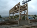
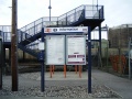 The entrance to St Andrews Road station from the road.
 -
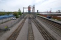
 Standing on the footbridge and looking in the direction of Bristol. The huge loading tower is for coal trains bound for Didcot Power Station.
 -
-
 The station and platform shelter are somewhat dwarfed by the industrial equipment that surrounds them.
 -
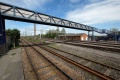
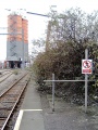 The platform has been halved by the addition of this barrier. Beyond this spot nature is doing it's best to reclaim the area.
 -
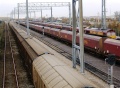
 It's only half two and the sun is already going down. 08685 trundles along the sidings on the 16.12.03.
 -
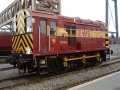
 A more conventional portrait of 08685.
 -
 The 08 backs onto a rake of coal hoppers.
 -
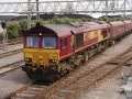
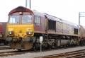 66247 awaits her next turn of duty.
 -
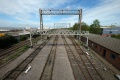
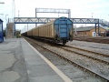 A look at the footbridge with a train of Cargowaggons underneath. The red brick building behind the train is the crew, control and signalling building.
 -
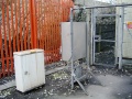 A couple of electrical boxes hidden underneath the footbridge.
 -
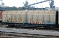 A better look at a graffiti covered wagon.
 -
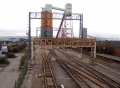
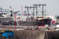
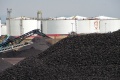
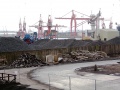 A general view of the stockpiles of coal, and the cranes used to unload ships.
 -
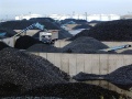 Coal as far as the eye can see... (well, as far as those petrol storage tanks anyway..) A truck is loaded for a local delivery.
 -
-
 Another look at the gleaming shunter as it stands at the end of a rake of Cargowaggons.
 -
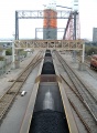 A look at one of the trains as it is loaded.
 -
 This structure spanning the tracks is all that remains of the overhead conveyor system seen in at the bottom of Neil Higson's photo above..


2005
13.7.05
-
 A visit to this station on 13.7.05 shows that the resident shunter was 09013.
 -
-

-
-

-
-
-


14.10.05


2.12.05

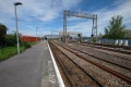
2018
3.5.18
-
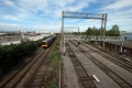
 With the closure of Didcot Power Station the yard is mostly unused, and was completely empty during my visit.
 -
-
-
 The station itself has been spruced up with the addition of customer service points and rubbish bins etc.
 -

-
-