Bath Road Viaduct: Difference between revisions
Jump to navigation
Jump to search
m moved Waterloo Road Viaduct to Bath Road Viaduct |
No edit summary |
||
| Line 1: | Line 1: | ||
<div style="float:right"> | <div style="float:right"> | ||
<googlemap lat="51. | <googlemap lat="51.188704" lon="-2.54385"> | ||
51.196275, -2.544327, Waterloo Road Viaduct | 51.196275, -2.544327, Waterloo Road Viaduct | ||
</googlemap> | </googlemap> | ||
| Line 6: | Line 6: | ||
'''To Radstock''': [[Forum Lane]]<br> | '''To Radstock''': [[Forum Lane]]<br> | ||
'''To Shepton Mallet''': [[Kilver Street Hill]]<br> | '''To Shepton Mallet''': [[Kilver Street Hill]]<br> | ||
== Gallery == | == Gallery == | ||
<gallery> | <gallery> | ||
Image:sheptonmallet1.jpg|An old 1989 photo I've found of the viaduct across Waterloo Road. Even in this poor quality photo it's easy to see where the viaduct had been doubled in width to accommodate growing traffic. | Image:sheptonmallet1.jpg|An old 1989 photo I've found of the viaduct across Waterloo Road. Even in this poor quality photo it's easy to see where the viaduct had been doubled in width to accommodate growing traffic. | ||
Image:BathRoadViaduct2.jpg|''© [[:Category:John Rawlings|John Rawlings]]'' | |||
</gallery> | </gallery> | ||
[[Category:John Rawlings]] | |||
[[Category:S&DJR]] | [[Category:S&DJR]] | ||
[[Category:Viaducts]] | [[Category:Viaducts]] | ||
Revision as of 16:33, 24 April 2012
<googlemap lat="51.188704" lon="-2.54385"> 51.196275, -2.544327, Waterloo Road Viaduct </googlemap>
To Radstock: Forum Lane
To Shepton Mallet: Kilver Street Hill
Gallery
-
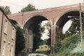 An old 1989 photo I've found of the viaduct across Waterloo Road. Even in this poor quality photo it's easy to see where the viaduct had been doubled in width to accommodate growing traffic.
 -