Durley Hill Footbridge: Difference between revisions
Jump to navigation
Jump to search
No edit summary |
No edit summary |
||
| Line 1: | Line 1: | ||
<div style="float:right"> | |||
<googlemap lat="51.429665" lon="-2.512007"> | |||
51.42616, -2.512672, Durley Hill Footbridge | |||
</googlemap> | |||
</div> | |||
'''To Bristol, the North or Wales''': [[A4174 Avon Ring Road]] | '''To Bristol, the North or Wales''': [[A4174 Avon Ring Road]] | ||
<br>'''To Bath''':[[Durley Lane]] | <br>'''To Bath''':[[Durley Lane]] | ||
== History == | == History == | ||
Revision as of 01:33, 8 November 2007
<googlemap lat="51.429665" lon="-2.512007"> 51.42616, -2.512672, Durley Hill Footbridge </googlemap>
To Bristol, the North or Wales: A4174 Avon Ring Road
To Bath:Durley Lane
History
Durley Hill Footbridge was the site of locomotive water troughs between 1898 and 1960.
Gallery
20.7.05
-
 This footbridge is sited along a footpath that runs from Durley Hill, Keynsham to the River Avon. ©James Hyde
 -
 A view of the bridge. ©James Hyde
 -
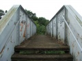
 A look at the steps. ©James Hyde
 -
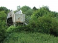 The bridge viewed from the other side. ©James Hyde
 -
 The view towards Keynsham with the Duke of Gloucester rushing towards the bridge. ©James Hyde
 -
 And the view towards Bristol with the Duke of Gloucester rushing away from the bridge. ©James Hyde
 -
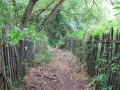
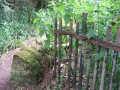
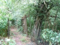 The next few photos show various footpaths and boundary fences at this location. ©James Hyde
 -
 ©James Hyde
 -
 ©James Hyde
 -
 ©James Hyde


