Oil Mills Bridge: Difference between revisions
Jump to navigation
Jump to search
Created page with '<div style="float:right"> <googlemap lat="51.733301" lon="-2.253656"> 51.740138, -2.253903, Oil Mills Bridge </googlemap> </div> '''To the Severn''': Ryeford Double Lock <br>…' |
No edit summary |
||
| Line 1: | Line 1: | ||
'''To the Severn''': [[Ryeford Double Lock]] | '''To the Severn''': [[Ryeford Double Lock]] | ||
<br>'''To the Thames''': [[Cloth Mills Bridge]] | <br>'''To the Thames''': [[Cloth Mills Bridge]] | ||
== Gallery == | |||
6.6.14 | |||
<gallery> | |||
Image:OilMillsBridge1.jpg|As viewed from the west. | |||
Image:OilMillsBridge2.jpg| | |||
Image:OilMillsBridge3.jpg|From the east. | |||
Image:OilMillsBridge4.jpg|The view west from the bridge. | |||
Image:OilMillsBridge5.jpg|And the view east. [[Cloth Mills Bridge]] is just visible in the distance. | |||
</gallery> | |||
[[Category:Stroudwater Navigation]] | [[Category:Stroudwater Navigation]] | ||
Revision as of 00:07, 31 December 2014
To the Severn: Ryeford Double Lock
To the Thames: Cloth Mills Bridge
Gallery
6.6.14
-
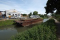 As viewed from the west.
 -
-
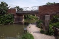
 From the east.
 -
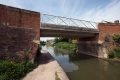
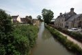
 The view west from the bridge.
 -
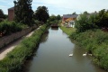
 And the view east. Cloth Mills Bridge is just visible in the distance.


