St Mary's Lock Bridge: Difference between revisions
Jump to navigation
Jump to search
Created page with '<div style="float:right"> <googlemap lat="51.711554" lon="-2.165879"> 51.718843, -2.1662, St Mary's Lock Bridge </googlemap> </div> '''To the Severn''': Beales Lock<br> '''To…' |
No edit summary |
||
| Line 6: | Line 6: | ||
'''To the Severn''': [[Beales Lock]]<br> | '''To the Severn''': [[Beales Lock]]<br> | ||
'''To the Thames''': [[St Mary's Lock]] | '''To the Thames''': [[St Mary's Lock]] | ||
== info == | |||
This bridge and lock sit alongside [[St Mary's Crossing Halt]] on the Gloucester to Swindon railway line. | |||
== 2014 == | == 2014 == | ||
29.1.14 | 29.1.14 | ||
<gallery> | <gallery> | ||
Image:StMary'sLockBridge1.jpg|The bridge viewed from the west. | |||
Image:StMary'sLockBridge2.jpg|Viewed from the steps of [[St Mary's Lock]]. | |||
Image:StMary'sLockBridge3.jpg|The view west from the top of the bridge. | |||
Image:StMary'sLock1.jpg|St Mary's Lock viewed from the bridge. | |||
</gallery> | </gallery> | ||
[[Category:Thames and Severn Canal]] | [[Category:Thames and Severn Canal]] | ||
Latest revision as of 22:33, 5 February 2014
<googlemap lat="51.711554" lon="-2.165879"> 51.718843, -2.1662, St Mary's Lock Bridge </googlemap>
To the Severn: Beales Lock
To the Thames: St Mary's Lock
info
This bridge and lock sit alongside St Mary's Crossing Halt on the Gloucester to Swindon railway line.
2014
29.1.14
-
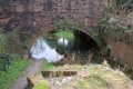
 The bridge viewed from the west.
 -
 Viewed from the steps of St Mary's Lock.
 -
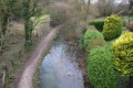 The view west from the top of the bridge.
 -
 St Mary's Lock viewed from the bridge.


