Wickwar: Difference between revisions
Jump to navigation
Jump to search
No edit summary |
No edit summary |
||
| Line 1: | Line 1: | ||
<div style="float:right"> | |||
<googlemap lat="51.6008" lon="-2.397552" zoom="14"> | |||
51.600387, -2.397702, Wickwar | |||
</googlemap> | |||
</div> | |||
'''To Yate''': [[Wickwar Tunnel]] | '''To Yate''': [[Wickwar Tunnel]] | ||
<br>'''To the North''': [[Wickwar Road]] | <br>'''To the North''': [[Wickwar Road]] | ||
Revision as of 10:34, 3 November 2007
<googlemap lat="51.6008" lon="-2.397552" zoom="14"> 51.600387, -2.397702, Wickwar </googlemap>
To Yate: Wickwar Tunnel
To the North: Wickwar Road
History
Opened on 8th July 1844. Closed to goods on 10th June 1963 and passengers on 4th January 1965.
3.9.06
-
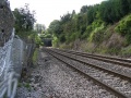 Dangling the camera over a fence and recording the view south from the site of Wickwar Goods Yard with the portal of Wickwar Tunnel visible in the distance.
 -
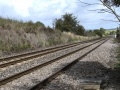 Looking north. Nothing remains of the station itself.
 -
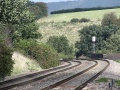 A telephoto shot north with the bridge over Station Road visible next to the signal.
 -
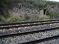 A recess opposite the goods yard marks the spot where a signalbox once stood.


