Marsh Junction: Difference between revisions
Jump to navigation
Jump to search
No edit summary |
No edit summary |
||
| Line 1: | Line 1: | ||
<div style="float:right"> | |||
<googlemap lat="51.451226" lon="-2.56196"> | |||
51.448137, -2.562325, Marsh Junction | |||
</googlemap> | |||
</div> | |||
'''To North Somerset Junction''': [[Cole Road]] | '''To North Somerset Junction''': [[Cole Road]] | ||
<br>'''To Bristol West Junction''':[[Marsh Junction Depot]] | <br>'''To Bristol West Junction''':[[Marsh Junction Depot]] | ||
Revision as of 10:26, 8 November 2007
<googlemap lat="51.451226" lon="-2.56196"> 51.448137, -2.562325, Marsh Junction </googlemap>
To North Somerset Junction: Cole Road
To Bristol West Junction:Marsh Junction Depot
To Radstock: Sandy Park Road
History
Marsh Junction was where the line for Pensford and Radstock diverged from the Bristol Avoiding Line. The whole area has now been obliterated under the Avonmeads and Spine Road developments.
Gallery
-
 Looking along the avoiding line in the direction of North Somerset Junction. Cole Road is just beyond the signals.
 -
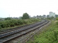
 The view south with Marsh Junction Depot visible in the background.

