West Town Lane: Difference between revisions
Jump to navigation
Jump to search
No edit summary |
|||
| Line 7: | Line 7: | ||
<br>'''To Radstock''': [[Manston Close]] | <br>'''To Radstock''': [[Manston Close]] | ||
== | == Gallery == | ||
4.1.06 | |||
<gallery> | <gallery> | ||
Image:westtownlane1.jpg|The railway crossed West Town Lane on a bridge. The bridge has long gone and the embankment leading to it has been replaced by a housing estate. This is the view towards Bristol. | Image:westtownlane1.jpg|The railway crossed West Town Lane on a bridge. The bridge has long gone and the embankment leading to it has been replaced by a housing estate. This is the view towards Bristol. | ||
Image:westtownlane2.jpg|Looking south and the bramble covered embankment is still in place. | Image:westtownlane2.jpg|Looking south and the bramble covered embankment is still in place. | ||
</gallery> | </gallery> | ||
[[Category:Bridges:Demolished]] | [[Category:Bridges:Demolished]] | ||
[[Category:B&NSR]] | [[Category:B&NSR]] | ||
Latest revision as of 20:13, 16 July 2008
<googlemap lat="51.429772" lon="-2.55724"> 51.426293, -2.557862, West Town Lane </googlemap>
To Bristol: Brislington
To Radstock: Manston Close
Gallery
4.1.06
-
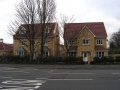 The railway crossed West Town Lane on a bridge. The bridge has long gone and the embankment leading to it has been replaced by a housing estate. This is the view towards Bristol.
 -
 Looking south and the bramble covered embankment is still in place.

