Maesknoll Lane: Difference between revisions
Jump to navigation
Jump to search
No edit summary |
No edit summary |
||
| Line 5: | Line 5: | ||
</div> | </div> | ||
'''To Bristol''': [[Whitchurch Halt]] | '''To Bristol''': [[Whitchurch Halt]] | ||
<br>'''To Radstock''': [[ | <br>'''To Radstock''': [[Hursley Hill]] | ||
== 10.5.05 == | == 10.5.05 == | ||
<gallery> | <gallery> | ||
Latest revision as of 16:24, 8 November 2007
<googlemap lat="51.394868" lon="-2.563419"> 51.391414, -2.564299, Maesknoll Lane </googlemap>
To Bristol: Whitchurch Halt
To Radstock: Hursley Hill
10.5.05
-
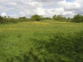 The view from the bridge at Maesknoll Lane looking north towards Whitchurch. The wide boundaries suggest that this would have once been quite a deep cutting.
 -
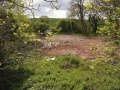 And the view south looking in the direction of Pensford.
 -
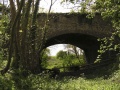 Two views of the bridge itself. This is the north aspect. (ie. I'm looking south)
 -
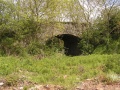 And the south aspect.


