Filton Junction: Difference between revisions
Jump to navigation
Jump to search
New page: <div style="float:right"> <googlemap lat="51.51168" lon="-2.560329"> 51.508996, -2.561209, Filton Junction </googlemap> </div> '''To Bristol''': Station Road<br> ... |
No edit summary |
||
| Line 6: | Line 6: | ||
'''To Bristol''': [[Station Road - Filton|Station Road]]<br> | '''To Bristol''': [[Station Road - Filton|Station Road]]<br> | ||
'''To Avonmouth''': [[Filton Chord]]<br> | '''To Avonmouth''': [[Filton Chord]]<br> | ||
'''To Wales''': [[A Bridge]]<br> | '''To Wales''': [[A Bridge(2)|A Bridge]]<br> | ||
'''To Yate or London''': [[Filton Curve]] | '''To Yate or London''': [[Filton Curve]] | ||
== 1960s == | == 1960s == | ||
Revision as of 17:41, 23 November 2007
<googlemap lat="51.51168" lon="-2.560329"> 51.508996, -2.561209, Filton Junction </googlemap>
To Bristol: Station Road
To Avonmouth: Filton Chord
To Wales: A Bridge
To Yate or London: Filton Curve
1960s
-
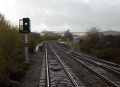
 Filton Junction in the early 1960's. This is the view south with Filton Junction Signal Box in the distance. © R.Cuff via P.Rendall

2004
-
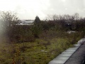
 All that's left of the approach to Filton Junction.
 -
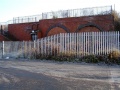
 The subway is blocked off.


Dec. 2006
-
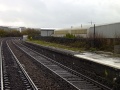
 The view south showing the remains of the South Wales platforms. The pointwork on the right of the photo is Filton Junction No 2 and is the start of Filton Chord and the line to Avonmouth. © Capt. Flack
 -
 A closer view. In the background is the massive MOD development at Filton Abbey Wood which caused the closure of Filton Junction station. © Capt. Flack
 -
 A view across the platforms showing some railings buried amongst the buddleia. Just visible in the background are the lines to Bristol Parkway. © Capt. Flack
 -
 Another view of the station showing remains of one of the platforms. © Capt. Flack


