Pilning Low Level: Difference between revisions
Jump to navigation
Jump to search
No edit summary |
No edit summary |
||
| Line 1: | Line 1: | ||
<div style="float:right"> | <div style="float:right"> | ||
<googlemap lat="51. | <googlemap lat="51.559197" lon="-2.62496"> | ||
51. | 51.556849, -2.626204, Pilning Low Level | ||
</googlemap> | </googlemap> | ||
</div> | </div> | ||
Revision as of 14:39, 7 December 2007
<googlemap lat="51.559197" lon="-2.62496"> 51.556849, -2.626204, Pilning Low Level </googlemap>
To Pilning Junction: Pilning Junction
To Severn Beach or New Passage Pier: Bank Road
History
Pilning Low Level was built on the site of the original Pilning station. (Which served the line to New Passage Pier). Opened on 9th July 1928. Closed on 23rd November 1964.
1960s
-
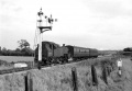
 Pilning Low Level with 6951 setting off in the direction of Pilning Junction. The road on the right leads to Bank Road © Gerald Peacock
 -
 The view towards Pilning Junction. On the right hand side of the photo is Station Road (with a sign warning motorists of a low bridge), while in the distance stock sits on the sidings at the junction. © Gerald Peacock


1972
-
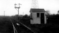
 The view from Pilning Low Level signal box. © Simon Whittingham
 -
 The inside of the signal box. © Simon Whittingham
 -
 The north west end of the station. © Simon Whittingham


2003-2005
-
 A 2003 view of the station site. The houses in the background are those visible in Gerald's photo at the top of the page.
 -
 The level crossing gatepost on the south side of the road was still standing on 13.4.04. The crossing gate from this location is now at the Didcot Railway Centre.
 -
 While on the other side of the road the gate was still in situ on the same date.


28.4.06
-
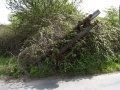 During a visit to Pilning station on 28.4.06 I noticed that the surviving level crossing gatepost has been involved in an accident. It was still there February the following year, albeit much more overgrown.
