Kings Weston Road: Difference between revisions
Jump to navigation
Jump to search
No edit summary |
|||
| Line 10: | Line 10: | ||
Image:Kings Weston Road1.jpg|Commonwealth Smelting No 6. 12.11.92. | Image:Kings Weston Road1.jpg|Commonwealth Smelting No 6. 12.11.92. | ||
</gallery> | </gallery> | ||
== | == 2004 == | ||
1.4.04 | |||
<gallery> | <gallery> | ||
Image:Kings Weston Road2.jpg|Looking West from '''Kings Weston Road'''. This used to lead to a rather large complex of sidings. It's out of bounds to the casual observer. | Image:Kings Weston Road2.jpg|Looking West from '''Kings Weston Road'''. This used to lead to a rather large complex of sidings. It's out of bounds to the casual observer. | ||
Revision as of 13:06, 21 February 2008
<googlemap lat="51.517556" lon="-2.691822"> 51.515259, -2.692047, Kings Weston Road </googlemap>
To Hallen Marsh Junction: Smoke Lane Level Crossing
To Hallen Marsh:
1990s
-
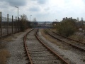
 Commonwealth Smelting No 6. 12.11.92.

2004
1.4.04
-
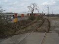
 Looking West from Kings Weston Road. This used to lead to a rather large complex of sidings. It's out of bounds to the casual observer.
 -
 The gates that protected the crossing.
 -
 Looking beyond the gates. These sidings crossed Smoke Lane before joining the rest of the network at Hallen Marsh Junction.


