Lawrence Hill Junction: Difference between revisions
Jump to navigation
Jump to search
New page: <div style="float:right"> <googlemap lat="51.45866" lon="-2.567024"> 51.458165, -2.567561, Lawrence Hill Junction </googlemap> </div> '''To Bristol''': Barrow Road<br> '''To Bath or th... |
No edit summary |
||
| Line 1: | Line 1: | ||
<div style="float:right"> | <div style="float:right"> | ||
<googlemap lat="51. | <googlemap lat="51.459302" lon="-2.567625"> | ||
51. | 51.45763, -2.568269, Lawrence Hill Junction | ||
</googlemap> | </googlemap> | ||
</div> | </div> | ||
Revision as of 00:13, 1 January 2008
<googlemap lat="51.459302" lon="-2.567625"> 51.45763, -2.568269, Lawrence Hill Junction </googlemap>
To Bristol: Barrow Road
To Bath or the North : A420 Lawrence Hill
1960s
-
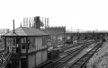 A wonderful photo of Lawrence Hill Junction. The lines behind the junction signal box led to Temple Meads and Barrow Road MPD, the lines in front served the Avon Street branch and St Philips station. The roof of Temple Meads is just visible beyond Barrow Road bridge. © David Gardner

2004
-
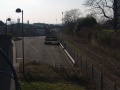
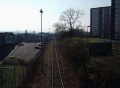 Two views showing the site of the junction. Everything except for a truncated Avon Street branch has been swept away.
 -