Jones: Difference between revisions
Jump to navigation
Jump to search
BristleGWR (talk | contribs) No edit summary |
BristleGWR (talk | contribs) No edit summary |
||
| Line 7: | Line 7: | ||
'''To the Southwest''': [[Cider Farm]]<br> | '''To the Southwest''': [[Cider Farm]]<br> | ||
== History == | == History == | ||
== | Given the unusual name 'Jones' this bridge enables Backwell Bow/Chapel Hill road to pass under the railway. | ||
== 2004 == | |||
13th December | |||
<gallery> | <gallery> | ||
Image:Jones1.jpg|Bristol is to the left in this pic. | |||
Image:Jones2.jpg|The other side of the bridge. | |||
Image:Jones3.jpg|Just in case anyone thinks I'm making up the name of this location... | |||
</gallery> | </gallery> | ||
[[Category:B&ER]] | [[Category:B&ER]] | ||
[[Category:Bridges]] | [[Category:Bridges]] | ||
Revision as of 20:01, 19 January 2008
<googlemap lat="51.423621" lon="-2.727635"> 51.423638, -2.727613, Jones </googlemap>
To Bristol: Backwell Green
To the Southwest: Cider Farm
History
Given the unusual name 'Jones' this bridge enables Backwell Bow/Chapel Hill road to pass under the railway.
2004
13th December
-
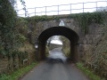
 Bristol is to the left in this pic.
 -
 The other side of the bridge.
 -
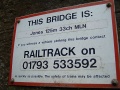 Just in case anyone thinks I'm making up the name of this location...


