Bonnington Walk: Difference between revisions
Jump to navigation
Jump to search
No edit summary |
|||
| Line 30: | Line 30: | ||
Image:Bonnington Road5.jpg|Work progresses on stabilizing the cutting. 31.8.06. | Image:Bonnington Road5.jpg|Work progresses on stabilizing the cutting. 31.8.06. | ||
Image:Bonnington Road6.jpg|[[158762]] cruises down [[:Category:Filton Bank|Filton Bank]]. | Image:Bonnington Road6.jpg|[[158762]] cruises down [[:Category:Filton Bank|Filton Bank]]. | ||
Image:Bonnington Road7.jpg|A view of the finished work. 9.12.06 | |||
</gallery> | </gallery> | ||
Revision as of 20:53, 30 October 2008
<googlemap lat="51.496347" lon="-2.568398"> 51.495132, -2.568977, Bonnington Road </googlemap>
To Bristol or Bath: Horfield
To Wales, The North or London: Stanley Farm Footbridge
1930s

1980s
-
A 1983 view from Lockleaze Road bridge with the remains of Horfield station and Bonnington Walk bridge visible in the distance. © P.D.Rendall
-
 The view of Lockleaze Road from Bonnington Walk bridge. © P.D.Rendall

2004
-

-
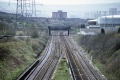
 Standing on the bridge and looking towards Bristol with Lockleaze Road bridge in the distance. The remains of the platforms of Horfield station visible below.
 -
 Looking along Bonnington Walk.
 -
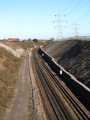
 Looking north and the severity of the 1 in 75 gradient of Filton Bank is plain to see.


2006
-
 The view north from Bonnington Walk bridge on the 16.3.06. Work was in progress to stabilize the sides of the cutting. Engineers were using a big digger and a shute to fill gabions, gradually building a high wall at the base of the cutting.
 -
 This photo was taken on a previous Sunday when the digger had just been delivered by road. It shows the true size of the beast!
 -
 Work progresses on stabilizing the cutting. 31.8.06.
 -
 158762 cruises down Filton Bank.
 -
 A view of the finished work. 9.12.06


