A Whitchurch Footpath: Difference between revisions
Jump to navigation
Jump to search
No edit summary |
No edit summary |
||
| Line 1: | Line 1: | ||
<div style="float:right"> | |||
<googlemap lat="51.4188" lon="-2.554665"> | |||
51.41583, -2.555137, Whitchurch Railway Path | |||
</googlemap> | |||
</div> | |||
'''To Bristol''': [[Longreach Grove]] | '''To Bristol''': [[Longreach Grove]] | ||
<br>'''To Radstock''': [[Tibbott Road]] | <br>'''To Radstock''': [[Tibbott Road]] | ||
== 28.4.06 == | |||
<gallery> | <gallery> | ||
Image:whitchurchfootpath1.jpg|The view from the footpath looking north towards Bristol. | Image:whitchurchfootpath1.jpg|The view from the footpath looking north towards Bristol. | ||
| Line 14: | Line 17: | ||
</gallery> | </gallery> | ||
[[Category: | [[Category:B&NSR]] | ||
Latest revision as of 15:58, 8 November 2007
<googlemap lat="51.4188" lon="-2.554665"> 51.41583, -2.555137, Whitchurch Railway Path </googlemap>
To Bristol: Longreach Grove
To Radstock: Tibbott Road
28.4.06
-
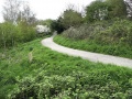
 The view from the footpath looking north towards Bristol.
 -
 Tuning around 180° and the path has been encroached on by people extending their gardens.
 -
 A diversion takes the path on a new route around the obstruction.
 -
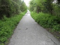 Having regained the old railway trackbed, this is the view south. Be careful where you put your feet!
 -
 And turning around 180° again shows a wall blocking the original route.
 -
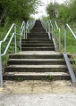 The railway path is reached by climbing this set of steps.


