Charfield Loops: Difference between revisions
Jump to navigation
Jump to search
No edit summary |
No edit summary |
||
| Line 1: | Line 1: | ||
<div style="float:right"><googlemap lat="51.632706" lon="-2.404718 | <div style="float:right"><googlemap lat="51.632706" lon="-2.404718"> | ||
51.632403, -2.404702, Charfield Loops | 51.632403, -2.404702, Charfield Loops | ||
</googlemap></div> | </googlemap></div> | ||
'''To Yate''': [[Wotton Road]] | '''To Yate''': [[Wotton Road]] | ||
<br>'''To the North''': [[Flour Mill]] | <br>'''To the North''': [[Flour Mill]] | ||
| Line 18: | Line 17: | ||
Image:Charfield Loops4.jpg|A zoomed view north showing signal B455 protecting the exit from the loops. | Image:Charfield Loops4.jpg|A zoomed view north showing signal B455 protecting the exit from the loops. | ||
</gallery> | </gallery> | ||
[[Category:B&GR]] | [[Category:B&GR]] | ||
[[Category:MR]] | [[Category:MR]] | ||
Revision as of 21:23, 13 October 2009
<googlemap lat="51.632706" lon="-2.404718">
51.632403, -2.404702, Charfield Loops
</googlemap>To Yate: Wotton Road
To the North: Flour Mill
Track Plans
-
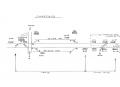 A track plan of Charfield Loops and surrounding area from 1988.

Gallery
3.9.06
-
 The southern end of the loops.
 -
 A footpath crosses the loops.
 -
 The view south from the middle of the footpath.
 -
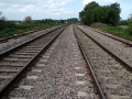 The view north.
 -
 A zoomed view north showing signal B455 protecting the exit from the loops.


