Parson Street: Difference between revisions
Jump to navigation
Jump to search
| Line 7: | Line 7: | ||
'''To the Southwest''': [[Bedminster Down Road]]<br> | '''To the Southwest''': [[Bedminster Down Road]]<br> | ||
== History == | == History == | ||
Opened on the 29th August [[1927]] as Parson Street | Opened on the 29th August [[1927]] as '''Parson Street Platform'''. The station was rebuilt as part of a project to quadruple the lines west from [[Temple Meads]] and reopened on 21st May [[1933]]. The suffix 'Platform' was dropped at the same time. The station buildings were demolished in January [[1971]]. | ||
== Track Plans == | == Track Plans == | ||
Revision as of 20:36, 9 February 2008
<googlemap lat="51.433197" lon="-2.608008"> 51.433317, -2.607837, Parson Street </googlemap>
To Bristol: Malago Vale Carriage Sidings
To the Southwest: Bedminster Down Road
History
Opened on the 29th August 1927 as Parson Street Platform. The station was rebuilt as part of a project to quadruple the lines west from Temple Meads and reopened on 21st May 1933. The suffix 'Platform' was dropped at the same time. The station buildings were demolished in January 1971.
Track Plans
-
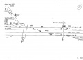 A track plan of Parson Street and surrounding area from 1988.

2004
-
The view from Parson Street roadbridge back towards the footbridge at Malago Vale. The new-build houses on the site of the old carriage sidings are protected from noise from the railway by a bloody big wall.
-
A general view along Parson Street Station. I'm stood where the station building once was. Look how the platform surface changes colour at the far end, signifying the length of train that calls here.
-
Standing at the end of the platforms and looking under the roadbridge.
-
The view from the Down platform with 150261 disappearing under Bartletts Bridge.
-
This electrical cabinet is underneath the stairway on the Up platform.
-
The footbridge has seen better times. Like a lot of the bridges in Bristol it once had a roof over the staircases.
-
This signal protects the junction between the loop and the mainline.
-
Looking along the Up slow/freight line. This line leads to the Portishead Branch.
-
And looking along the scar of the Down Slow.
-
This electrical cabinet stands in the trackbed of the Down Slow.
-
A view of one of the platform shelters.
-
The other platform shelter is a different (older) design.
-
The platform ends are fenced off part way along. I decided to risk trespassing because I wanted to archive the bridge and my digital zoom just ain't good enough to do it from this distance.
-
A view of the bridge that carries Bedminster Down Road across the line. On the right is an abutment from another bridge that used to cross here. At that time everything on the left of this picture was just fields.
-
A close up of the abutment.
-
A view back along the platforms, looking towards Bristol.
-
The view back along the station from the Down platform.