Mangotsfield: Difference between revisions
Jump to navigation
Jump to search
No edit summary |
|||
| Line 1: | Line 1: | ||
<div style="float:right"> | <div style="float:right"> | ||
<googlemap lat="51. | <googlemap lat="51.468178" lon="-2.482738"> | ||
51.475743, -2.483275, Mangotsfield | 51.475743, -2.483275, Mangotsfield | ||
</googlemap> | </googlemap> | ||
| Line 26: | Line 26: | ||
Image:D70-1.jpg|[[Class 45|Peak]] [[D70]] stands at the station during August [[1965]]. ''© [[:Category:Robin Summerhill|Robin Summerhill]]'' | Image:D70-1.jpg|[[Class 45|Peak]] [[D70]] stands at the station during August [[1965]]. ''© [[:Category:Robin Summerhill|Robin Summerhill]]'' | ||
</gallery> | </gallery> | ||
== 1970s == | |||
<gallery> | |||
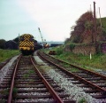
Image:Steve Selwood2.jpg|Some photos showing track lifting activities at the station. ''© [[:Category:Steve Selwood|Steve Selwood]]'' | |||
Image:Steve Selwood3.jpg|''© [[:Category:Steve Selwood|Steve Selwood]]'' | |||
Image:Steve Selwood4.jpg|''© [[:Category:Steve Selwood|Steve Selwood]]'' | |||
</gallery> | |||
== 2004 == | == 2004 == | ||
12.4.04 | 12.4.04 | ||
| Line 54: | Line 59: | ||
[[Category:Roger Newport]] | [[Category:Roger Newport]] | ||
[[Category:Peter Rendall]] | [[Category:Peter Rendall]] | ||
[[Category:Steve Selwood]] | |||
[[Category:Stations]] | [[Category:Stations]] | ||
[[Category:Stations:Closed]] | [[Category:Stations:Closed]] | ||
[[Category:Robin Summerhill]] | [[Category:Robin Summerhill]] | ||
Revision as of 19:01, 18 February 2010
<googlemap lat="51.468178" lon="-2.482738"> 51.475743, -2.483275, Mangotsfield </googlemap>
To Bristol: Rodway Hill
To Bath: Mangotsfield South Junction
To the North:Rodway Hill Bridge
History
Opened on the 4th August 1869 and closed on the 7th March 1966.
1960s
-
 A Brush Type 4 approaches Mangotsfield from the north. © Clive Moore
 -
 A wonderful shot of a Crosti boilered 9f on the approach to the station. © Clive Moore
 -
 A closer look at the same train. The 9f was 92026 which was originally crosti boilered but later changed to normal boiler while still retained the crosti looking front end. © Clive Moore
 -
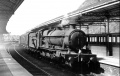
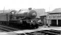
 A Peak approaches Mangotsfield from the Bristol direction, passing various goods wagons in the sidings. © Clive Moore
 -
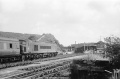 Looking in the other direction, and with Mangotsfield station as a backdrop, the Peak passes by with a north bound service. © Clive Moore
 -
 This photo was taken at the north end of the station from the gate from the car park. A Hymek drags a failed Peak north. © Clive Moore
 -
 The view from platform 2 with a Peak approaching from Bristol. © Peter Rendall/Past Track Publications
 -
 Class 14 D9525 waits in platform 4 for the road to Bristol after shunting at Bath Green Park. © Peter Rendall/Past Track Publications
 -
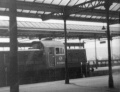
 The view from the station approach towards platforms 1 & 2 © Peter Rendall/Past Track Publications
 -
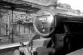
 82037 stands at Mangotsfield station. This loco was also photographed by Gerald Peacock at Temple Meads. © Roger Newport
 -
-
-
 44963 forms the IV39 on the 24th August 1962. © Roger Newport
 -


1970s
-
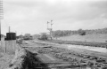
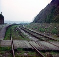 Some photos showing track lifting activities at the station. © Steve Selwood
 -
-


2004
12.4.04
-
-
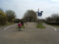
 A sculpture at the Bristol end of the station.
 -
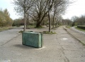
 The remains of the underpass are still visible.
 -
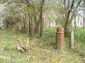 A row of cut-off cast iron pillars that once supported a canopy. The nearest one was home to a nesting coal tit at the time of my visit.
 -
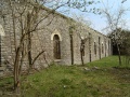 The remains of the station on the Bristol - Yate side. This is from a courtyard between the Bristol-Yate and Bristol-Bath triangle.
 -
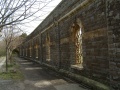 And the platform-side remains of the station on the Bristol - Yate side.
 -
 Looking through one of the windows into the area where the station buildings used to be.
 -
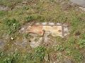 There are bits of tiled surface still visible at various places along the main platform.


2006
8.5.06
-

-
 The view towards Bristol.
 -
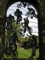
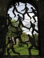 Window sculptures.
 -
 My family can be seen having a picnic through this one :)


