Berkeley Road: Difference between revisions
Jump to navigation
Jump to search
BristleGWR (talk | contribs) No edit summary |
No edit summary |
||
| Line 29: | Line 29: | ||
[[Category:B&GR]] | [[Category:B&GR]] | ||
[[Category:Junctions]] | [[Category:Gloucester:Junctions]] | ||
[[Category:MR]] | [[Category:MR]] | ||
[[Category:Gerald Peacock]] | [[Category:Gerald Peacock]] | ||
[[Category:Stations:Closed]] | [[Category:Gloucester:Stations:Closed]] | ||
Revision as of 18:10, 29 December 2008
<googlemap lat="51.702726" lon="-2.408409" zoom="14" width="185" height="500">
51.700066, -2.408967, Berkeley Road
</googlemap>To Yate: A38
To the North: Ammunitions Factory
To Sharpness: 00-22 SAW
History
Opened as Dursley and Berkeley Road on 8th July 1844. Renamed on 1st June 1845. Became a junction station in 1875 with the opening of a branch to Sharpness. A footbridge was erected in 1883, linking the up and down platforms. The Sharpness branch closed to passengers in November 1964 and Berkeley Road closed to passengers on 4th January 1965 with the withdrawal of local services on the Bristol to Gloucester route. Closed to goods on 1st November 1966.
1960s
-
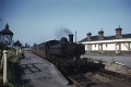
 Royal Scot 46162 screams south through Berkeley Road heading for Bristol. This loco was withdrawn in May 1964. On the left a pannier tank and coaches with a service for Sharpness can be seen. © Gerald Peacock
 -
 Pannier tank 8717. This engine also features on the Berkeley page. © Gerald Peacock


3.9.06
-
 The view south from Berkeley Road Junction showing the cleared site of Berkeley station. The Sharpness branch peels off to the right. In the distance the A38 crosses the railway.
 -
 A zoomed view showing the road bridge in better detail.
 -
 A view showing the Sharpness branch.
 -
 The view north showing Berkeley Road Junction.
 -
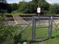 The public footpath across the railway from where I took the photos.
 -
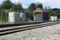 The relay room and related equipment.
 -
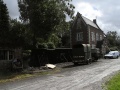 The station masters house is now in use as a private residence.
 -
 An old weighbridge hut was slowly crumbling away in the yard.


