Saniger Lane: Difference between revisions
Jump to navigation
Jump to search
No edit summary |
No edit summary |
||
| Line 2: | Line 2: | ||
51.71089, -2.473726, Saniger Lane | 51.71089, -2.473726, Saniger Lane | ||
</googlemap></div> | </googlemap></div> | ||
'''To Sharpness''': [[Sharpness]] | '''To Sharpness''': [[Sharpness]] | ||
<br>'''To Berkeley Road''': [[Station Road]] | <br>'''To Berkeley Road''': [[Station Road]] | ||
== 6.9.04 == | == 6.9.04 == | ||
<gallery> | <gallery> | ||
Image:Saniger Lane1.jpg|The bridge across Saniger Lane at Newtown in [[w:Sharpness|Sharpness]]. The site of [[Sharpness|Sharpness station]] is to the left in this pic. | Image:Saniger Lane1.jpg|The bridge across Saniger Lane at Newtown in [[w:Sharpness|Sharpness]]. The site of [[Sharpness|Sharpness station]] is to the left in this pic. | ||
</gallery> | </gallery> | ||
[[Category:Gloucester:Bridges]] | |||
[[Category:Bridges]] | |||
[[Category:S&WR]] | [[Category:S&WR]] | ||
Revision as of 22:48, 2 March 2009
<googlemap lat="51.710797" lon="-2.47349" zoom="14" width="185" height="500">
51.71089, -2.473726, Saniger Lane
</googlemap>To Sharpness: Sharpness
To Berkeley Road: Station Road
6.9.04
-
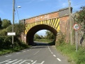 The bridge across Saniger Lane at Newtown in Sharpness. The site of Sharpness station is to the left in this pic.
