Bathampton Station and Junction: Difference between revisions
Jump to navigation
Jump to search
No edit summary |
No edit summary |
||
| Line 1: | Line 1: | ||
<div style="float:right"> | <div style="float:right"> | ||
<googlemap lat="51. | <googlemap lat="51.39128" lon="-2.320175"> | ||
51.398416, -2.320669, Bathampton Station and Junction | 51.398416, -2.320669, Bathampton Station and Junction | ||
</googlemap> | </googlemap> | ||
| Line 12: | Line 12: | ||
<gallery> | <gallery> | ||
Image:Bathampton Junction Track Plan 1988.jpg|A track plan of Bathampton Junction and surrounding area from [[1988]] | Image:Bathampton Junction Track Plan 1988.jpg|A track plan of Bathampton Junction and surrounding area from [[1988]] | ||
</gallery> | |||
== 1960s == | |||
<gallery> | |||
Image:Bathampton Junction14.jpg|''© [[:Category:Ian W Ross|Ian W Ross]]'' | |||
</gallery> | </gallery> | ||
== 1970s == | == 1970s == | ||
| Line 38: | Line 42: | ||
[[Category:Andy Kirkham]] | [[Category:Andy Kirkham]] | ||
[[Category:John Rawlings]] | [[Category:John Rawlings]] | ||
[[Category:Ian W Ross]] | |||
[[Category:Stations:Closed]] | [[Category:Stations:Closed]] | ||
[[Category:Nick Thayer]] | [[Category:Nick Thayer]] | ||
Revision as of 20:02, 17 January 2010
<googlemap lat="51.39128" lon="-2.320175"> 51.398416, -2.320669, Bathampton Station and Junction </googlemap>
To Bath: Meadow Lane
To London: Middle Hill Tunnel
To Bradford Junction: Limpley Stoke
History
Opened on 2nd February 1857. Closed to goods on 10th June 1963 and passengers on 3rd October 1966. Both Bathampton and Bathampton West signalboxes were replaced by a single box on 21st September 1956. There were sidings to a timber mill on the south side of the station which came into use on 10th October 1922.
Track Plans
-
 A track plan of Bathampton Junction and surrounding area from 1988

1960s

1970s
-
 A couple of photos of Westerns taken at the loop to the west of Bathampton. © Andy Kirkham
 -


2005
All my photos taken on 29.6.05
-
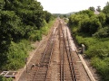
 Looking in the direction of Bath Spa from the bridge at Mill Lane. The signals protect Bathampton Junction while the loop is the Up Loop and has a 15mph speed limit.
 -
 An old platelayers hut is abandoned at the lineside.
 -
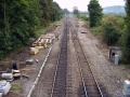
 Looking east from the bridge gives a great view of the junction. Bathampton Station stood on this spot. On its removal the junction was modified to allow trains on the Bradford on Avon section to travel at higher speeds.
 -
 Zooming in on the view showing various relay rooms and cabinets. The sign with the cross notifies drivers that AWS is not provided at the UPL exit signal B477.
 -
 Zooming out and a London bound HST passes by.
 -
 An aerial view of the junction. The line to Bradford on Avon curves towards the bottom left of the photo while the main Bristol to London railway line crosses the photo from left to right. © John Rawlings


2008
November.
-
 Photos showing track replacement work at Bathampton Junction. © Nick Thayer
 -


