Weston Super Mare: Difference between revisions
Jump to navigation
Jump to search
No edit summary |
|||
| Line 1: | Line 1: | ||
<div style="float:right"> | <div style="float:right"> | ||
<googlemap lat="51. | <googlemap lat="51.337637" lon="-2.971544"> | ||
51.344354, -2.972078, Weston Super Mare | 51.344354, -2.972078, Weston Super Mare | ||
</googlemap> | </googlemap> | ||
| Line 10: | Line 10: | ||
== Track Plan == | == Track Plan == | ||
<gallery> | <gallery> | ||
Image:Weston Super MareMap1936.jpg|A plan of the WSM area from [[1936]]. | |||
Image:WSM Approach Map1.jpg|A map showing the approach to Weston Super Mare and [[Locking Road]] stations from [[1953]]. | Image:WSM Approach Map1.jpg|A map showing the approach to Weston Super Mare and [[Locking Road]] stations from [[1953]]. | ||
Image:Weston Super Mare Track Plan 1988.jpg|A trackplan of the WSM area from [[1988]]. | Image:Weston Super Mare Track Plan 1988.jpg|A trackplan of the WSM area from [[1988]]. | ||
</gallery> | </gallery> | ||
== 1960s == | == 1960s == | ||
<gallery> | <gallery> | ||
| Line 22: | Line 22: | ||
Image:WSM15.jpg|'''5954''' Faendre Hall stands at the station with a service for [[Temple Meads|Bristol]]. This loco was withdrawn in October [[1963]]. ''[[:Category:John Thorn|John Thorn]]'' | Image:WSM15.jpg|'''5954''' Faendre Hall stands at the station with a service for [[Temple Meads|Bristol]]. This loco was withdrawn in October [[1963]]. ''[[:Category:John Thorn|John Thorn]]'' | ||
</gallery> | </gallery> | ||
== 1985 == | == 1985 == | ||
<gallery> | <gallery> | ||
| Line 44: | Line 43: | ||
Image:WSM12.jpg|This building at Weston Super Mare is the original [[:Category:B&ER|Bristol & Exeter Railway]] signal box and is a listed building. ''© [[:Category:Andrew Ross|Andrew Ross]]'' | Image:WSM12.jpg|This building at Weston Super Mare is the original [[:Category:B&ER|Bristol & Exeter Railway]] signal box and is a listed building. ''© [[:Category:Andrew Ross|Andrew Ross]]'' | ||
</gallery> | </gallery> | ||
[[Category:B&ER]] | [[Category:B&ER]] | ||
[[Category:David Burrell]] | [[Category:David Burrell]] | ||
Revision as of 19:10, 18 January 2010
<googlemap lat="51.337637" lon="-2.971544"> 51.344354, -2.972078, Weston Super Mare </googlemap>
To Bristol: Great Western Bridge/Hildesheim Bridge
To the Southwest: Clevedon Road - Weston Super Mare
History
Track Plan
-
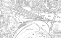 A plan of the WSM area from 1936.
 -
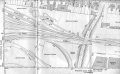 A map showing the approach to Weston Super Mare and Locking Road stations from 1953.
 -
 A trackplan of the WSM area from 1988.


1960s
-
 WSM Station Master, Mr G. L. Richings, says goodbye to two retiring motor drivers, Messrs. Phippen and Ward. The parcels staff at the back are Messrs. Habberfield, Priddle, Hurse, Kennedy, Downe, Phillips and Lloyd. 1963
 -
Another view of the loco as it waits to leave. © Clive Moore
-
The same spot but this time with a steam engine about to leave for Bristol. Behind the engine, another train stands in the bay platform. © Clive Moore
-
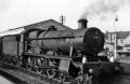 5954 Faendre Hall stands at the station with a service for Bristol. This loco was withdrawn in October 1963. John Thorn


1985
-
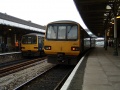
Looking east from Weston Super Mare with 33031 awaiting work. © David Burrell
2004
-
A look at the station building. © Andrew Ross
-
The view east is now blocked by the Hildesheim Bridge. The car park on the right seems to have rails buried under the tarmac. © Andrew Ross
-
Looking towards Weston gas works which was once rail-connected. The route of the first railway to reach Weston Super Mare went from the spot where the photograph was taken in a straight line towards those gas works. © Andrew Ross
-
A look at the mightly fine footbridge. Thank heavens this has been kept intact. © Andrew Ross
-
A closer look at the staircase. © Andrew Ross
-
The view inside the footbridge. © Andrew Ross
-
-
The view south along the station.
-
The bay alongside platform 2. The track plan at Weston Super Mare doesn't allow direct access into the bay from the mainline and anything using it would have to make two reversals.
-
Standing at the south end of the station and looking north.
-
Looking south from Weston Super Mare station.

-
This building at Weston Super Mare is the original Bristol & Exeter Railway signal box and is a listed building. © Andrew Ross