Barrow Road MPD: Difference between revisions
Jump to navigation
Jump to search
No edit summary |
No edit summary |
||
| Line 1: | Line 1: | ||
<div style="float:right"> | <div style="float:right"> | ||
<googlemap lat="51. | <googlemap lat="51.447695" lon="-2.570715"> | ||
51.455023, -2.571316, Barrow Road MPD | 51.455023, -2.571316, Barrow Road MPD | ||
</googlemap> | </googlemap> | ||
| Line 6: | Line 6: | ||
'''To Temple Meads''': [[Barton Hill TMD]]<br> | '''To Temple Meads''': [[Barton Hill TMD]]<br> | ||
'''To Lawrence Weston Junction''': [[Barrow Road]] | '''To Lawrence Weston Junction''': [[Barrow Road]] | ||
== | == Track Plans == | ||
<gallery> | |||
Image:St Philips 1903.jpg|A track plan of Barrow Road and the surrounding railway sidings and engine sheds from [[1903]]. | |||
</gallery> | |||
== Gallery == | == Gallery == | ||
<gallery> | <gallery> | ||
Revision as of 22:47, 30 January 2010
<googlemap lat="51.447695" lon="-2.570715"> 51.455023, -2.571316, Barrow Road MPD </googlemap>
To Temple Meads: Barton Hill TMD
To Lawrence Weston Junction: Barrow Road
Track Plans
-
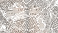 A track plan of Barrow Road and the surrounding railway sidings and engine sheds from 1903.

Gallery
-
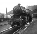
 51217 on shed in the early 1950s. This loco was used on the branch to Avon Street. c/o Ian Allcroft
 -
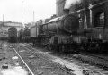
 A view of the shed taken in July 1960 showing locos no 40501 and 44775 closest to the camera. 40501 was withdrawn one month later while 44775 lasted until November 1967. The wagon in the background would have been used for inspecting tunnels.
 -
 43040 waits her next turn of duty during 1962. © Roger Porch
 -
 6854 works up a head of steam at Barrow Road on 13.7.65. 45281 is behind.
 -
 44296 awaits it's next turn of duty sometime in either late '64 or early '65. © George Gardiner
 -
 7782 on shed. © George Gardiner
 -


2003
-
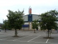 A bingo hall stands at the spot previously occupied by the concrete coal loading tower seen in George Gardiner's photos above.
