Pensford Colliery: Difference between revisions
Jump to navigation
Jump to search
New page: <div style="float:right"> <googlemap lat="51.365189" lon="-2.548399"> 51.362309, -2.547026, Pensford Colliery 51.361405, -2.550362, Pensford Colliery (site of) </googlemap> </div> '''To Br... |
No edit summary |
||
| Line 1: | Line 1: | ||
<div style="float:right"> | <div style="float:right"> | ||
<googlemap lat="51. | <googlemap lat="51.355274" lon="-2.548656"> | ||
51.362309, -2.547026, Pensford Colliery | 51.362309, -2.547026, Pensford Colliery | ||
51.361405, -2.550362, Pensford Colliery (site of) | 51.361405, -2.550362, Pensford Colliery (site of) | ||
Latest revision as of 22:53, 5 February 2010
<googlemap lat="51.355274" lon="-2.548656"> 51.362309, -2.547026, Pensford Colliery 51.361405, -2.550362, Pensford Colliery (site of) </googlemap>
To Bristol: Wick Lane
To Radstock: Clutton
History
Pensford Colliery site is the only coalmine in the Somerset Coalfield to retain a nearly complete set of mine buildings, although most of these have been converted to residential use. Photos taken on 19.2.05
Gallery
-
 The remains of Pensford Colliery.
 -
 The winding house.
 -
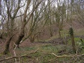
 The trackbed at Pensford Colliery looking north.
 -
 The trackbed looking south. A landslip has blocked the view any further than this.


