Temple Meads: Difference between revisions
Jump to navigation
Jump to search
No edit summary |
|||
| Line 128: | Line 128: | ||
Image:Temple Meads45.jpg|A Superb view south across the rooftops at Temple Meads with Totterdown on the hill in the distance and the yellow 'Banana Bridge' on the right. ''© [[:Category:Inks|Inks]]'' | Image:Temple Meads45.jpg|A Superb view south across the rooftops at Temple Meads with Totterdown on the hill in the distance and the yellow 'Banana Bridge' on the right. ''© [[:Category:Inks|Inks]]'' | ||
Image:Temple Meads46.jpg|And an equally impressive view east with the post office machinery bridge dominating the scene. ''© [[:Category:Inks|Inks]]'' | Image:Temple Meads46.jpg|And an equally impressive view east with the post office machinery bridge dominating the scene. ''© [[:Category:Inks|Inks]]'' | ||
Image:Temple Meads47.jpg|Another roof-top view, this time showing the throat of the station as an [[w:Inter City 125|HST]] leaves with a service for [[Paddington|London]]. 26.10.05 ''© [[:Category:Mark Lippiatt|Mark Lippiatt]]'' 26.10.05 | Image:Temple Meads47.jpg|Another roof-top view, this time showing the throat of the station as an [[w:Inter City 125|HST]] leaves with a service for [[Paddington railway station|London]]. 26.10.05 ''© [[:Category:Mark Lippiatt|Mark Lippiatt]]'' 26.10.05 | ||
Image:Temple Meads48.jpg|A ground level shot of the west end of the station taken on the 7.10.05 | Image:Temple Meads48.jpg|A ground level shot of the west end of the station taken on the 7.10.05 | ||
Image:143613-4.jpg|[[143613]] awaits its next duty at the east end of the station on the same day. | Image:143613-4.jpg|[[143613]] awaits its next duty at the east end of the station on the same day. | ||
Image:66086-1.jpg|[[66086]] at Temple Meads with a train load of cars from [[Royal Portbury Dock]]. 13.6.05. ''© [[:Category:Andrew Ross|Andrew Ross]]'' | Image:66086-1.jpg|[[66086]] at Temple Meads with a train load of cars from [[Royal Portbury Dock]]. 13.6.05. ''© [[:Category:Andrew Ross|Andrew Ross]]'' | ||
</gallery> | </gallery> | ||
== 2007 == | == 2007 == | ||
<gallery> | <gallery> | ||
Revision as of 19:00, 12 February 2010
<googlemap lat="51.443469" lon="-2.580757"> 51.449059, -2.580199, Temple Meads 51.446465, -2.578697, Bath Road Depot 51.449514, -2.582731, Temple Meads Old Station 51.450958, -2.581186, Temple Meads Goods </googlemap>
To the Southwest: Cattle Market Road
To Wales, the North or Bath: River Avon
History
Track Plans
-
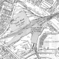 A Track plan of Temple Meads and surrounding area from 1903.

1900s - 1950s
-
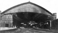 A view of the south end of the station taken circa 1911.
 -
 An early view of Temple Meads taken from an old postcard. It shows horse drawn taxis and a Cabmans shelter. The spire on the clock tower was destroyed by a German incendiary bomb in an air raid on 3 January 1941.
 -
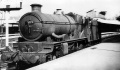
 Castle class 5069 Isambard Kingdom Brunel at the east end of TM. This loco was built in 1938. All Castles had smokebox number plates fitted by January 1951 so this photo was taken before that date. © Michelle Howe
 -


1960s
-
-
 Loco 82037 stands at Temple Meads with a short freight. © Gerald Peacock.
 -

-
 1025 County of Radnor stands at the same spot as the above photo. New in January 1947. Withdrawn in February 1963 while allocated to Shrewsbury shed.
 -

-
 Another view of the east end of Temple Meads, this time with Jubilee 45659 Drake awaiting the right of way. This loco was cut up in 1963.
 -

-
 Probably taken at the same time D815 is seen carrying The Bristolian headboard.
 -
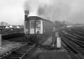
 D7010 waits next to a very big pile of mail sacks. © John Thorn
 -
 A very grubby Royal Scot 46151. This loco was withdrawn in December 1962. © Roger Porch
 -
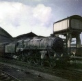
 Pioneer Hymek D7000 at the same end of the station in 1962. The Blue Circle Cement depot on Avon Street is visible behind. © Roger Porch
 -
 North British Class 22 D6354 pulls a freight out of Temple Meads Goods. This loco ended her days in the scrap line at St Philips Marsh.
 -
 5024 Carew Castle awaits departure while a Warship departs from the then platform 9. This loco was withdrawn in May 1962. © Roger Porch
 -
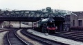
 7036 Taunton Castle at the east end of the station. © Roger Porch
 -
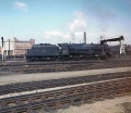
 A couple of Peaks (D20 closest to the camera) stand at Temple Meads with the northbound Devonian. © Roger Porch
 -
 A very grubby Std Class 5 No 73012 waits with a train for the North East in 1962. © Roger Porch
 -
 1021 County of Montgomery stands at the east end of Temple Meads. She was new in December 1946 and withdrawn from St Philips Marsh in November 1963.
 -
 7019 Fowey Castle stands at Temple Meads during May 1963. She was withdrawn four months later.
 -

-
 The 11.20 train for Worcester leaves Temple Meads on the 11th October 1969.
 -


1970s
-
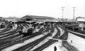
 An early 1970s shot of Temple Meads that shows a Post Office conveyor system under construction. The 37s are returning from near Hewish with an empty fly ash train. The ash was used during the construction of the M5 motorway. © Simon Whittingham
 -
 Andy Kirkham managed to catch a similar working. © Andy Kirkham
 -
 Another image from the early 1970s showing D818 under the post office bridge with construction work going on above her. The loco was withdrawn in 1972 but not scrapped until November 1985. In the meantime she provided countless spares to the other preserved examples.© Simon Whittingham
 -
 D33 enters Temple Meads with a parcels train. © Laurence Spring
 -
 D814 awaits work in the station. © Andy Kirkham
 -
 As does D812. © Andy Kirkham
 -
 D1034 at the south end of the station. © Andy Kirkham
 -

-
 D24 trundles through with a parcels train. © Andy Kirkham
 -
 The prototype HST visits the station. © Andy Kirkham
 -
 A Class 31, on a parcels train, pulls alongside. © Andy Kirkham
 -
 'Hampshire' Class 205 1123 waits at Temple Meads with a service to Portsmouth Harbour. © Andy Kirkham
 -

-
 A Western shunts vans. © Andy Kirkham
 -

-
-
-

-
 40081 makes a rare visit to Temple Meads on 25.9.75. © Phil Bidwell
 -
 D1001 Western Pathfinder at the west end of the station. 4.8.76 © Dave Higson
 -
-
 08185 shunts a mail train on 30.4.77.
 -
-
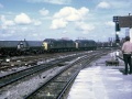
 An unidentified Class 50 waits to head south in the late 1970s.


1980s
-
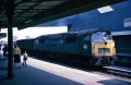
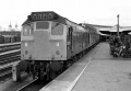
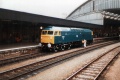
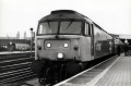
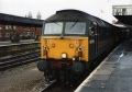
 47015 waits her next turn of duty at the east end of Temple Meads.
 -
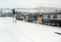 A cold snap hit Bristol on 9.4.82. © Adrian Henry
 -
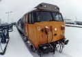 Another view of the Class 50 on the same day. © Adrian Henry
 -
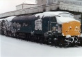 And another one taken on the same day. © Adrian Henry
 -
-
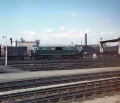
 A general view of the west end of Temple Meads taken in the 80s. © Clive Moore
 -
 May 1988 A HST heading south. © Clive Moore
 -
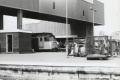
 155312 unit leaves the confines of Bath Road Depot after servicing on the 25.7.88.
 -

-

-
-
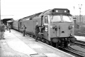
 47648 simmers at platform 12 with the guard looking on in the background. 2.10.88
 -
-
 A DMU is loaded with mail as it awaits a green light for Cardiff. 52048 3.8.88
 -
 08646 shunts parcels.
 -
 47631 pokes out from underneath the Post Office machinery bridge on the 15.5.88.
 -

-
 47458 heads a parcels train on the 6.2.89.
 -
 A night time shot of 47580 County Of Essex, complete with the Cockney Sparrow, after being transferred from Stratford in East London. 6.2.89.


1990s
-
-
 While her Fragonset sister 47709 rests at the other end of Temple Meads.
 -
 47783 Saint Peter awaits the off with a RES service sometime in the late 90s.
 -

-


2001
-
 47849 uncouples from her train at the west end of Temple Meads on 29.6.01.

2003
-
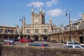 Temple Meads as viewed from Bristol & Exeter House on the 24.6.03 © Mike P
 -
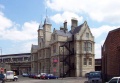 A view of Bristol & Exeter House which stands on the approach to Temple Meads. For more photos of this building see This Page.
 -
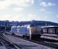
 The view from the east end of the station. Andy Spencer catches a couple of Class 50s on a Pathfinder tour at the end of 2003. There's some more photos of these locos on the Bristol East Power Box page.


2004
-
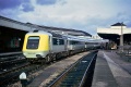
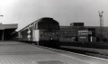
 The ex-Royal Mail building can also be seen in the background of this photo of 143619. 7.10.04.
 -


2005
-
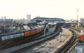
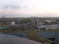
 A Superb view south across the rooftops at Temple Meads with Totterdown on the hill in the distance and the yellow 'Banana Bridge' on the right. © Inks
 -
 And an equally impressive view east with the post office machinery bridge dominating the scene. © Inks
 -
 Another roof-top view, this time showing the throat of the station as an HST leaves with a service for London. 26.10.05 © Mark Lippiatt 26.10.05
 -
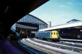
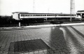
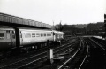
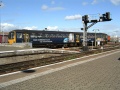
 A ground level shot of the west end of the station taken on the 7.10.05
 -
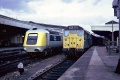
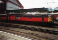
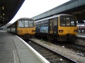
 143613 awaits its next duty at the east end of the station on the same day.
 -


2007
-
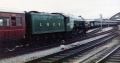
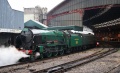 Lord Nelson on the Cathedrals Express. 9.5.07. © Andy Mitchell
