This Way to the Forums! Join in and Post :)
And an Archive of the earlier Forum! This one is read only but brilliant stuff!
Monksdale Road: Difference between revisions
Jump to navigation
Jump to search
BristleGWR (talk | contribs) No edit summary |
No edit summary |
||
| Line 1: | Line 1: | ||
<div style="float:right"> | <div style="float:right"> | ||
<googlemap lat="51. | <googlemap lat="51.366422" lon="-2.377596"> | ||
51.373597, -2.378272, Monksdale Road | 51.373597, -2.378272, Monksdale Road | ||
</googlemap> | </googlemap> | ||
</div> | </div> | ||
'''To Bath''': [[ | '''To Bath''': [[Melcombe Road]]<br> | ||
'''To Radstock''': [[Hiscocks Drive]]<br> | '''To Radstock''': [[Hiscocks Drive]]<br> | ||
== Gallery == | == Gallery == | ||
<gallery> | <gallery> | ||
Image:Monksdale Road1.jpg|The gap in the road where a railway bridge used to be. 21.2.10 | |||
Image:Monksdale Road2.jpg|The view in the direction of [[Bath Green Park|Bath]]. | |||
Image:Monksdale Road3.jpg|The view in the direction of [[Devonshire Tunnel]]. | |||
</gallery> | </gallery> | ||
[[Category:S&DJR]] | [[Category:S&DJR]] | ||
[[Category:Bridges:Demolished]] | [[Category:Bridges:Demolished]] | ||
Revision as of 20:13, 21 February 2010
<googlemap lat="51.366422" lon="-2.377596"> 51.373597, -2.378272, Monksdale Road </googlemap>
To Bath: Melcombe Road
To Radstock: Hiscocks Drive
Gallery
-
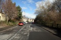 The gap in the road where a railway bridge used to be. 21.2.10
 -
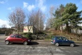 The view in the direction of Bath.
 -
 The view in the direction of Devonshire Tunnel.


