Devonshire Tunnel: Difference between revisions
Jump to navigation
Jump to search
No edit summary |
No edit summary |
||
| Line 1: | Line 1: | ||
<div style="float:right"> | <div style="float:right"> | ||
<googlemap lat="51. | <googlemap lat="51.362671" lon="-2.365923"> | ||
51.369691, -2.366567, Devonshire Tunnel | 51.369691, -2.366567, Devonshire Tunnel | ||
</googlemap> | </googlemap> | ||
| Line 16: | Line 16: | ||
Image:Devonshire Tunnel2.jpg|Looking towards the tunnel in 2008. The cutting has been filled and the portal buried. ''© [[:Category:John Rawlings|John Rawlings]]'' | Image:Devonshire Tunnel2.jpg|Looking towards the tunnel in 2008. The cutting has been filled and the portal buried. ''© [[:Category:John Rawlings|John Rawlings]]'' | ||
</gallery> | </gallery> | ||
== 2010 == | |||
<gallery> | |||
Image:Devonshire Tunnel3.jpg|The view towards [[Bath Green Park|Bath]] from above the tunnel portal. The brick pillar is an access shaft to the tunnel below. 21.2.10 | |||
</gallery> | |||
== External Links == | |||
* [http://www.twotunnels.org.uk/index.html Two Tunnels Greenway] | |||
[[Category:Linear Park]] | |||
[[Category:S&DJR]] | [[Category:S&DJR]] | ||
[[Category:Tunnels]] | [[Category:Tunnels]] | ||
[[Category:John Rawlings]] | [[Category:John Rawlings]] | ||
Revision as of 22:21, 21 February 2010
<googlemap lat="51.362671" lon="-2.365923"> 51.369691, -2.366567, Devonshire Tunnel </googlemap>
To Bath: Maple Grove
To Radstock: Watery Bottom Viaduct
History
Devonshire tunnel is 447 yards long.
1970s
-
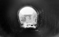 The view from inside Devonshire Tunnel looking back towards Bath. The bridge in the background is that at Maple Grove. © John Rawlings

2008
-
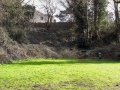 Looking towards the tunnel in 2008. The cutting has been filled and the portal buried. © John Rawlings

2010
-
 The view towards Bath from above the tunnel portal. The brick pillar is an access shaft to the tunnel below. 21.2.10
