Newbridge Road: Difference between revisions
Jump to navigation
Jump to search
No edit summary |
No edit summary |
||
| Line 1: | Line 1: | ||
<div style="float:right"> | <div style="float:right"> | ||
<googlemap lat="51. | <googlemap lat="51.381531" lon="-2.411242"> | ||
51.389044, -2.411821, Newbridge Road | 51.389044, -2.411821, Newbridge Road | ||
</googlemap> | </googlemap> | ||
| Line 6: | Line 6: | ||
'''To Bristol or the North''': [[Bridge 28]] | '''To Bristol or the North''': [[Bridge 28]] | ||
<br>'''To Bath Green Park''': [[Platelayers Hut]] | <br>'''To Bath Green Park''': [[Platelayers Hut]] | ||
== Gallery == | == Gallery == | ||
28.7.07 | 28.7.07 | ||
| Line 13: | Line 12: | ||
Image:Newbridge Road2.jpg|The view east. | Image:Newbridge Road2.jpg|The view east. | ||
</gallery> | </gallery> | ||
[[Category:Bridges]] | [[Category:Bridges]] | ||
[[Category:Bristol and Bath Railway Path]] | [[Category:Bristol and Bath Railway Path]] | ||
[[Category:MR]] | [[Category:MR]] | ||
Revision as of 16:19, 21 March 2010
<googlemap lat="51.381531" lon="-2.411242"> 51.389044, -2.411821, Newbridge Road </googlemap>
To Bristol or the North: Bridge 28
To Bath Green Park: Platelayers Hut
Gallery
28.7.07
-
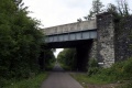 The view west. (towards Bristol)
 -
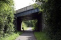 The view east.

