Westerleigh Sidings: Difference between revisions
Jump to navigation
Jump to search
No edit summary |
No edit summary |
||
| Line 4: | Line 4: | ||
</googlemap> | </googlemap> | ||
</div> | </div> | ||
'''To Mangotsfield''': [[ | '''To Mangotsfield''': [[M4-2|M4]] | ||
<br>'''To Yate''':[[Dewshill Wood]] | <br>'''To Yate''':[[Dewshill Wood]] | ||
== Track Plans == | == Track Plans == | ||
Latest revision as of 16:43, 30 March 2012
<googlemap lat="51.503026" lon="-2.447376"> 51.500889, -2.447977, Westerleigh Sidings </googlemap>
To Mangotsfield: M4
To Yate:Dewshill Wood
Track Plans
-
 A track plan of the Westerleigh area from 1988.

1990s
-

-
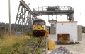 56050 under the loading bay. 30.7.92. © Dave Higson


2001
-
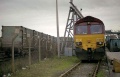 66040 stands at the refuse terminal with the last ever train to use it. 30.3.01 © Dave Higson

2006
-
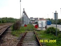
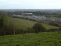 A general view of the Murco oil terminal. This was built on the site of Westerleigh sidings.
 -
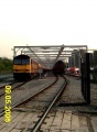
 The south end of the oil depot. The M4 crosses the railway on a bridge. The chimney of Parkfield Colliery dominates the horizon.
 -
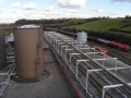 The view north from on top of one of the distilate tanks.
 -
 A Class 60 stands at the north end of the oil depot. © Peter Ho.
 -
 Just to the north of the Murco oil terminal is the now disused Avon County Council Refuse Transfer Station. © Peter Ho.


