Speedwell Colliery: Difference between revisions
Jump to navigation
Jump to search
No edit summary |
No edit summary |
||
| Line 7: | Line 7: | ||
== Maps == | == Maps == | ||
<gallery> | <gallery> | ||
Image:SpeedwellColliery1.jpg|An 1880s map of | Image:SpeedwellColliery1.jpg|An 1880s map of Speedwell Colliery. [[Belgium Colliery]] is visible bottom right of the map. | ||
</gallery> | </gallery> | ||
[[Category:Collieries]] | [[Category:Collieries]] | ||
Revision as of 18:19, 29 April 2012
<googlemap lat="51.459943" lon="-2.527456"> 51.46739, -2.528186, Speedwell Colliery </googlemap>
To Kingswood Junction: Kingswood Junction
Maps
-
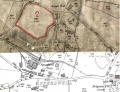 An 1880s map of Speedwell Colliery. Belgium Colliery is visible bottom right of the map.
