Canons Marsh: Difference between revisions
Jump to navigation
Jump to search
No edit summary |
No edit summary |
||
| Line 1: | Line 1: | ||
'''To Ashton Junction''': [[Gasferry Road Level Crossing]] | '''To Ashton Junction''': [[Gasferry Road Level Crossing]] | ||
== History == | == History == | ||
| Line 28: | Line 23: | ||
Image:Canons Marsh7.jpg|There is some old track buried in the tarmac east of the shed, but even this is disappearing as the harbourside is redeveloped. | Image:Canons Marsh7.jpg|There is some old track buried in the tarmac east of the shed, but even this is disappearing as the harbourside is redeveloped. | ||
</gallery> | </gallery> | ||
== 2012 == | |||
14.9.12 | |||
<gallery> | |||
Image:Canonswharf1.jpg|Preserved rails alongside a redeveloped Canons Wharf. | |||
</gallery> | |||
== External Links == | == External Links == | ||
[http://www.at-bristol.org.uk/explore/default.htm Explore @ Bristol] | [http://www.at-bristol.org.uk/explore/default.htm Explore @ Bristol] | ||
Latest revision as of 22:59, 12 April 2018
To Ashton Junction: Gasferry Road Level Crossing
History
Opened in October 1906, and one of the first reinforced concrete buildings in the country, the Grade II listed goods shed at Cannons Wharf became an integral part of the harbourside redevelopment when it was transformed in 2000 into explore@Bristol.
The shed measured 540ft by 133ft and could hold 97 wagons which were unloaded with the help of eight electric cranes and three 30-cwt electric hoists.
1960s

1990s
23.11.96
-
 Two views of the goods shed from the 1990s. The area was being used for car parking. © Aztec West
 -


2004
9.5.04
-
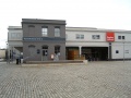 Cannons Marsh goods shed has become explore@Bristol.
 -
 An IMAX theatre has been built inside this globe.
 -
 An old weighbridge has been left in the courtyard but other than this there's very little that would give away that this used to be a goods shed.
 -
 There is some old track buried in the tarmac east of the shed, but even this is disappearing as the harbourside is redeveloped.


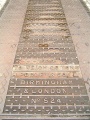
2012
14.9.12
-
 Preserved rails alongside a redeveloped Canons Wharf.
