Berkeley Road: Difference between revisions
Jump to navigation
Jump to search
No edit summary |
No edit summary |
||
| Line 1: | Line 1: | ||
<div style="float:right"><googlemap lat="51.702726" lon="-2.408409" zoom="14" width="200" height="500" overview="yes"> | |||
51.700066, -2.408967, Berkeley Road | |||
</googlemap></div> | |||
'''To Yate''': [[00-22 SAW]] | '''To Yate''': [[00-22 SAW]] | ||
<br>'''To the North''': [[Coaley Junction]] | <br>'''To the North''': [[Coaley Junction]] | ||
Revision as of 18:34, 1 November 2007
<googlemap lat="51.702726" lon="-2.408409" zoom="14" width="200" height="500" overview="yes">
51.700066, -2.408967, Berkeley Road
</googlemap>To Yate: 00-22 SAW
To the North: Coaley Junction
To Sharpness: Berkeley Loop Junction
1960s
-

-
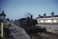 Pannier tank 8717. This engine also features on the Berkeley page. © Gerald Peacock


3.9.06
-
 The view south from Berkeley Road Junction showing the cleared site of Berkeley station. The Sharpness branch peels off to the right. In the distance the A38 crosses the railway.
 -
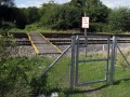
 A view showing the Sharpness branch.
 -
 The view north showing Berkeley Road Junction.
 -
 The public footpath across the railway from where I took the photos.
 -
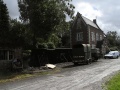 The station masters house is now in use as a private residence.
 -
 An old weighbridge hut was slowly crumbling away in the yard.


