Wallbridge Upper Lock: Difference between revisions
Jump to navigation
Jump to search
No edit summary |
No edit summary |
||
| Line 1: | Line 1: | ||
'''To the Severn''': [[Wallbridge Bridge]] | '''To the Severn''': [[Wallbridge Bridge]] | ||
<br>'''To the Thames''': [[Dr Newton's Way]] | <br>'''To the Thames''': [[Dr Newton's Way]] | ||
== 2009 == | == 2009 == | ||
<gallery> | <gallery> | ||
Image:UpperWallbridgeLock3.jpg|The unrestored lock as viewed from under [[Wallbridge Bridge]]. | Image:UpperWallbridgeLock3.jpg|The unrestored lock as viewed from under [[Wallbridge Bridge]]. 26.1.09 | ||
Image:UpperWallbridgeLock2.jpg|And the view from on top of it. | Image:UpperWallbridgeLock2.jpg|And the view from on top of it. | ||
Image:UpperWallbridgeLock4.jpg|The view east from the second lock gate. | Image:UpperWallbridgeLock4.jpg|The view east from the second lock gate. | ||
Image:UpperWallbridgeLock5.jpg|And the view west. | Image:UpperWallbridgeLock5.jpg|And the view west. | ||
</gallery> | |||
== 2012 == | |||
<gallery> | <gallery> | ||
Image:UpperWallbridgeLock6.jpg|A now restored lock and a view of the basin beyond. 8.2.12 | |||
Image:UpperWallbridgeLock7.jpg|The view from the basin towards the lock. The remains of the approach Road to [[Stroud Wallgate]] station, which crossed the canal at this point, can be seen in the background. | |||
</gallery> | |||
[[Category:Thames and Severn Canal]] | [[Category:Thames and Severn Canal]] | ||
Revision as of 22:49, 10 July 2022
To the Severn: Wallbridge Bridge
To the Thames: Dr Newton's Way
2009
-
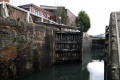 The unrestored lock as viewed from under Wallbridge Bridge. 26.1.09
 -
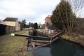
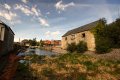
 And the view from on top of it.
 -
 The view east from the second lock gate.
 -
 And the view west.


2012
-
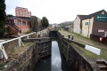
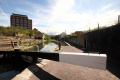 A now restored lock and a view of the basin beyond. 8.2.12
 -
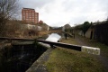
 The view from the basin towards the lock. The remains of the approach Road to Stroud Wallgate station, which crossed the canal at this point, can be seen in the background.

