Brandy Bottom Colliery: Difference between revisions
Jump to navigation
Jump to search
No edit summary |
No edit summary |
||
| Line 1: | Line 1: | ||
<div style="float:right"> | |||
<googlemap lat="51.495439" lon="-2.458277"> | |||
51.492319, -2.45921, Brandy Bottom Colliery | |||
</googlemap> | |||
</div> | |||
'''To Mangotsfield''': [[Shortwood Brickworks]] | '''To Mangotsfield''': [[Shortwood Brickworks]] | ||
<br>'''To Yate''':[[Coxgrove Hill]] | <br>'''To Yate''':[[Coxgrove Hill]] | ||
Revision as of 17:38, 5 November 2007
<googlemap lat="51.495439" lon="-2.458277"> 51.492319, -2.45921, Brandy Bottom Colliery </googlemap>
To Mangotsfield: Shortwood Brickworks
To Yate:Coxgrove Hill
History
One of the oldest collieries in the area, this pit was originally known as Brandy Bottom Pit, before becoming known as Parkfield South Colliery. By 1899, and as Parkfield Colliery (which was to the north) expanded, all coal was extracted from the northern pithead while Brandy Bottom was retained only for pumping and ventilation. The pit finally closed in 1936.
1990s Gallery
-
 The view north along the remains of the Midland Railway route. © Clive Moore
 -
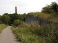
 The chimney of Brandy Bottom Colliery © Clive Moore
 -
 The remains of an old winding wheel has been placed alongside the cyclepath. © Clive Moore


2005 Gallery
-
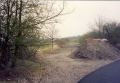
 The 2005 view north.
 -
 The octagonal top of the chimney.
 -
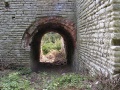 The remains of the horizontal engine house.
 -
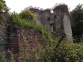 The remains of an old Cornish engine house.
 -


