Siston Hill Colliery: Difference between revisions
Jump to navigation
Jump to search
No edit summary |
No edit summary |
||
| Line 1: | Line 1: | ||
<div style="float:right"> | |||
<googlemap lat="51.465398" lon="-2.477674"> | |||
51.463072, -2.478104, Siston Hill Colliery | |||
</googlemap> | |||
</div> | |||
'''To Bristol or the North''': [[Siston Common]] | '''To Bristol or the North''': [[Siston Common]] | ||
<br>'''To Bath''': [[Norman Road]] | <br>'''To Bath''': [[Norman Road]] | ||
== Gallery == | == Gallery == | ||
<gallery> | <gallery> | ||
| Line 9: | Line 11: | ||
Image:Siston Hill Colliery2.jpg|The view along the trackbed in the direction of Bristol. | Image:Siston Hill Colliery2.jpg|The view along the trackbed in the direction of Bristol. | ||
</gallery> | </gallery> | ||
[[Category:Bristol and Bath Railway Path]] | [[Category:Bristol and Bath Railway Path]] | ||
[[Category:Collieries]] | [[Category:Collieries]] | ||
[[Category:MR]] | [[Category:MR]] | ||
Revision as of 19:06, 5 November 2007
<googlemap lat="51.465398" lon="-2.477674"> 51.463072, -2.478104, Siston Hill Colliery </googlemap>
To Bristol or the North: Siston Common
To Bath: Norman Road
Gallery
-
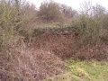 The remains of Siston Hill Colliery alongside the route of the Cyclepath.
 -
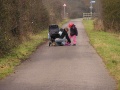 The view along the trackbed in the direction of Bristol.

