Twerton Viaduct: Difference between revisions
Jump to navigation
Jump to search
No edit summary |
No edit summary |
||
| Line 1: | Line 1: | ||
<div style="float:right"> | |||
<googlemap lat="51.383674" lon="-2.394505"> | |||
51.380955, -2.394612, Twerton Viaduct | |||
</googlemap> | |||
</div> | |||
'''To Bristol, the North or Wales''': [[Twerton Short Tunnel]] | '''To Bristol, the North or Wales''': [[Twerton Short Tunnel]] | ||
<br>'''To Bath''':[[Twerton]] | <br>'''To Bath''':[[Twerton]] | ||
== History == | == History == | ||
Revision as of 22:09, 7 November 2007
<googlemap lat="51.383674" lon="-2.394505"> 51.380955, -2.394612, Twerton Viaduct </googlemap>
To Bristol, the North or Wales: Twerton Short Tunnel
To Bath:Twerton
History
Twerton Viaduct is 638 yards long.
Gallery
-
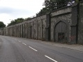 Standing at the west end of Twerton Viaduct, looking east. Twerton Bypass was built by the GWR, removing the need for through road transport to negotiate the village.
 -
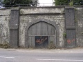 Arches once used as storage space.
 -
 Further east along the viaduct is a section that was repaired after being hit by nine bombs during WWII.
 -
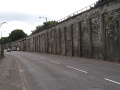
 Further east, I'm standing at the junction with Rackfield Place.
 -
 Looking west from the same spot. The doors in the viaduct originally opened to housing, but are now industrial units.
 -
 Closed industrial units next to Twerton Station.


