Thornbury: Difference between revisions
Jump to navigation
Jump to search
No edit summary |
|||
| Line 1: | Line 1: | ||
'''To Yate''': [[Grovesend Tunnel]] | '''To Yate''': [[Grovesend Tunnel]] | ||
<br>'''End of the Line!''' | <br>'''End of the Line!''' | ||
Latest revision as of 22:09, 28 March 2026
To Yate: Grovesend Tunnel
End of the Line!
History
Opened on 2nd September 1872. Closed to passengers on 19th June 1944 and goods on 20th June 1966.
1960s
-
 Wagons being shunted at Thornbury. © Gerald Peacock
 -
 A loco being turned on the turntable. © Gerald Peacock
 -
 A cement train stands within the station area. © Gerald Peacock


2005
4.2.05
-
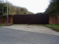 The railway embankment comes to an end on Midland Road at this rather impressive set of gates. A peak through the gaps showed masses of brambles, quite impenetrable.
 -
 The view in the opposite direction. The trackbed has had a housing estate built on it.
 -
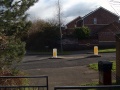 Closer to the Thornbury station area and the route is cut across by Link Road.
 -
 Looking towards the centre of Thornbury from Link Road. The route of the railway passes behind houses and rises on an embankment.
 -
 A railway bridge survives right in the middle of the housing estate, effectively chopping it in half.
 -
 The bridge viewed from the other side.
 -
 Standing on the bridge and looking in the direction of Yate.
 -
 Standing on the bridge and looking in the direction of Thornbury.
 -
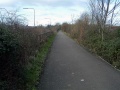
 The route then runs behind industrial estates along Midland Way. This is the view in the direction of Yate.
 -
 And the view in the direction of Thornbury.
 -
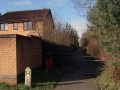
 As the route approaches the site of Thornbury station it is absorbed by Midland Way.
 -
 Turning around and looking at the approach to Thornbury station.
 -
 Just to the east of the last photo is an underpass. This looks like the bottom half of the masonry is original and the top half new. Looking on old maps suggests a footpath crossed the railway at this point. Don't quote me on that though!
 -
 And just for completeness, the bridge viewed from the other side.


