Burdett Close Crossing: Difference between revisions
Jump to navigation
Jump to search
No edit summary |
No edit summary |
||
| Line 1: | Line 1: | ||
'''To Gloucester''': [[Stonehouse]]<br> | '''To Gloucester''': [[Stonehouse]]<br> | ||
'''To Swindon''' [[Brown's Lane]] | '''To Swindon''' [[Brown's Lane]] | ||
Latest revision as of 22:38, 4 April 2026
To Gloucester: Stonehouse
To Swindon Brown's Lane
Note
A location where I've made the name up. If you know the correct one, or what the locals call it, please get in touch. moo@moocow.me.uk
Gallery
12.2.09
-
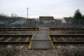
 Two views of the crossing.
 -
-
 The view towards Stonehouse.
 -
 A zoomed view showing the proximity to the station.
 -
 The view towards Stroud.
 -
 A zoomed view.
 -
 The bridge at Brown's Lane.


