Pensford Viaduct: Difference between revisions
Jump to navigation
Jump to search
No edit summary |
No edit summary |
||
| Line 1: | Line 1: | ||
'''To Bristol''': [[ | <div style="float:right"> | ||
<googlemap lat="51.374406" lon="-2.550802"> | |||
51.370682, -2.551532, Pensford Viaduct | |||
</googlemap> | |||
</div> | |||
'''To Bristol''': [[Pensford]] | |||
<br>'''To Radstock''': [[Wick Lane]] | <br>'''To Radstock''': [[Wick Lane]] | ||
== History == | |||
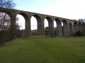
'''Pensford Viaduct''' is 330 yards long. | '''Pensford Viaduct''' is 330 yards long. | ||
| Line 21: | Line 24: | ||
[[Category:Viaducts]] | [[Category:Viaducts]] | ||
[[Category: | [[Category:B&NSR]] | ||
Revision as of 16:34, 8 November 2007
<googlemap lat="51.374406" lon="-2.550802"> 51.370682, -2.551532, Pensford Viaduct </googlemap>
To Bristol: Pensford
To Radstock: Wick Lane
History
Pensford Viaduct is 330 yards long.
All photos taken on 19.2.05. If anyone has a photo of the viaduct with a train on it that I can use please get in touch.
In 1971 pupils of the then new Wellsway School walked the viaduct. Pictures can be found Here
Gallery
-
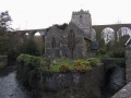 Pensford Viaduct acts as a backdrop to the entire village.
 -
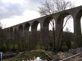 A variety of views of the viaduct itself. This is the view west with Bristol to the right.
 -
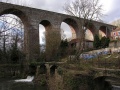 More of the viaduct as viewed from the village of Pensford.
 -
 Passing through an arch and looking south.
 -
 More views of the viaduct.
 -
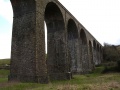
 Viewed from Old Down the viaduct is lit up by the sun during a break in the cloud cover.


