Station Road - Coalpit Heath: Difference between revisions
Jump to navigation
Jump to search
New page: <div style="float:right"> <googlemap lat="51.524072" lon="-2.470293"> 51.52028, -2.471108, Station Road </googlemap> </div> '''To Bristol''': Coalpit Heath <br>'''To Yate or London''':... |
|||
| Line 12: | Line 12: | ||
Image:Station Road Coalpit Heath1.jpg|Bristol is to the left in this photo. | Image:Station Road Coalpit Heath1.jpg|Bristol is to the left in this photo. | ||
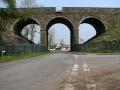
Image:Station Road Coalpit Heath2.jpg|Viewed from the other side. | Image:Station Road Coalpit Heath2.jpg|Viewed from the other side. | ||
Image:Station Road Coalpit Heath3.jpg|A much better shot of the bridge taken on '''10.5.06''' | Image:Station Road Coalpit Heath3.jpg|A much better shot of the bridge taken on '''10.5.06''' after [[w:Network Rail|Network Rail]] cut back all the vegetation. The embankments either side of the viaduct were stabilized by the addition of gabions. | ||
</gallery> | </gallery> | ||
[[Category:Bridges]] | [[Category:Bridges]] | ||
[[Category:GWR]] | [[Category:GWR]] | ||
Revision as of 21:29, 17 November 2007
<googlemap lat="51.524072" lon="-2.470293"> 51.52028, -2.471108, Station Road </googlemap>
To Bristol: Coalpit Heath
To Yate or London: Coalpit Heath Viaduct
History
Gallery
-
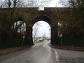 Bristol is to the left in this photo.
 -
 Viewed from the other side.
 -
 A much better shot of the bridge taken on 10.5.06 after Network Rail cut back all the vegetation. The embankments either side of the viaduct were stabilized by the addition of gabions.


