Winterbourne: Difference between revisions
Jump to navigation
Jump to search
New page: <div style="float:right"> <googlemap lat="51.519212" lon="-2.495098"> 51.517863, -2.495506, Winterbourne </googlemap> </div> '''To Bristol''': Harcombe Hill <br>'''To Yate or London'''... |
No edit summary |
||
| Line 1: | Line 1: | ||
<div style="float:right"> | <div style="float:right"> | ||
<googlemap lat="51. | <googlemap lat="51.519372" lon="-2.497416"> | ||
51. | 51.517529, -2.497866, Winterbourne | ||
</googlemap> | </googlemap> | ||
</div> | </div> | ||
Revision as of 18:18, 18 November 2007
<googlemap lat="51.519372" lon="-2.497416"> 51.517529, -2.497866, Winterbourne </googlemap>
To Bristol: Harcombe Hill
To Yate or London: Huckford Viaduct
History
Opened on the 1st July 1903 and closed on the 3rd April 1961.
1900s
-
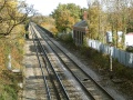
 A view of the station as it once was. The bridge at Harcombe Hill is visible behind the footbridge, while the bridge at Dragon Road can be seen beyond that.

2003
-
 Standing on the bridge at Station Road/Harcombe Hill and looking east. This building is all that remains of Winterbourne station. The premises were in use by a car repairer.
 -
 A view from the road of the station building as of Oct 2003.
 -
 The station building as viewed from the site of the old up platform. 2.12.03


8.11.05
-
 An HST makes a signal stop alongside the old station on 8.11.05. In the background work proceeds on stabilizing the embankment through Coalpit Heath.

27.1.06
-
 The view on 21st July 2006 shows that the garage has closed and the building is locked up, once again out of use.
