Dragon Road: Difference between revisions
Jump to navigation
Jump to search
No edit summary |
No edit summary |
||
| Line 4: | Line 4: | ||
</googlemap> | </googlemap> | ||
</div> | </div> | ||
'''To Bristol''': [[Mill Road]] | '''To Bristol or Wales''': [[Mill Road]] | ||
<br>'''To Yate or London''': [[Winterbourne Goods Yard]] | <br>'''To Yate or London''': [[Winterbourne Goods Yard]] | ||
== History == | == History == | ||
Revision as of 21:18, 21 November 2007
<googlemap lat="51.518197" lon="-2.505655"> 51.516661, -2.506063, Dragon Road </googlemap>
To Bristol or Wales: Mill Road
To Yate or London: Winterbourne Goods Yard
History
There was a gruesome discovery in a house in Dragon Road on 30th July 1906. The Rev, Henry Alban Brown used an open razor to murder his wife Maria Catherine and her sister Mary Elliott, before comitting suicide.
Nov. 2003
-
 A general view along Dragon Rd in Winterbourne Down.
 -
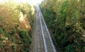 The view east. The bridge just visible in the distance is Harcombe Hill.


Feb. 2004
-
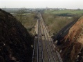
 What a difference a couple of months makes! This is the view east with Harcombe Hill in the distance. Compare this photo to the tree-lined one above... amazing!
 -
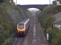
 Looking west in the direction of Bristol Parkway. In the distance is the bridge at Curtis Lane. The bridge at Mill Road can be seen where the sign with a T on it is in the photo. Beyond that is Winterbourne Viaduct, with the motorway just visible running right to left.
 -
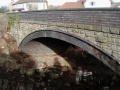 This view of the bridge was impossible to get the last time I visited.


Nov. 2005
-
 Getting on for two years later and whatever the engineers started here almost two years ago is still continuing. By all accounts the residents of Dragon Road are somewhat pissed off by the continuing noise and disruption.
