Station Road - Coalpit Heath: Difference between revisions
Jump to navigation
Jump to search
No edit summary |
No edit summary |
||
| Line 4: | Line 4: | ||
</googlemap> | </googlemap> | ||
</div> | </div> | ||
'''To Bristol or Wales''': [[Coalpit Heath]] | '''To Bristol or Wales''': [[Coalpit Heath Viaduct]] | ||
<br>'''To Yate or London''': [[Coalpit Heath | <br>'''To Yate or London''': [[Coalpit Heath]] | ||
== History == | == History == | ||
It was originally planned to span this location with an eight arch viaduct, but the presence of old mine workings led the engineers to believe that the ground could become unstable and so the embankments were extended and a bridge built. The foundations for the bridge were also sunk far below the coal seams. | It was originally planned to span this location with an eight arch viaduct, but the presence of old mine workings led the engineers to believe that the ground could become unstable and so the embankments were extended and a bridge built. The foundations for the bridge were also sunk far below the coal seams. | ||
Revision as of 22:21, 21 November 2007
<googlemap lat="51.524072" lon="-2.470293"> 51.52028, -2.471108, Station Road </googlemap>
To Bristol or Wales: Coalpit Heath Viaduct
To Yate or London: Coalpit Heath
History
It was originally planned to span this location with an eight arch viaduct, but the presence of old mine workings led the engineers to believe that the ground could become unstable and so the embankments were extended and a bridge built. The foundations for the bridge were also sunk far below the coal seams.
Gallery
-
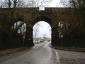
 Bristol is to the right in this photo.
 -
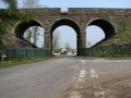
 Viewed from the other side.
 -
 A much better shot of the bridge taken on 10.5.06 after Network Rail cut back all the vegetation. The embankments either side of the viaduct were stabilized by the addition of gabions.


